
Isolated Strong Tornado Possible With Supercells Targeting Central South Dakota Including Pierre and Aberdeen Wednesday Between 5 PM and 10 PM
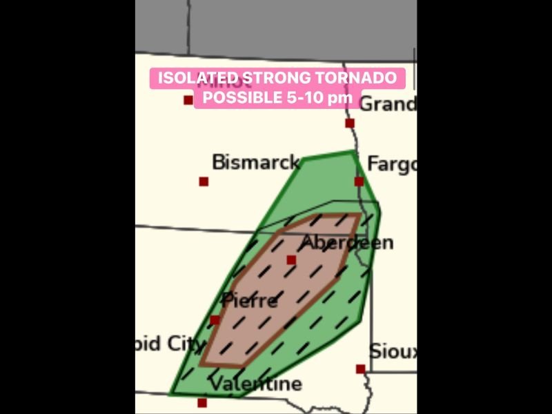
CENTRAL SOUTH DAKOTA — An isolated strong tornado is possible across central South Dakota Wednesday evening between 5 PM and 10 PM, with a hatched tornado risk zone centered directly over the Pierre to Aberdeen corridor indicating the highest concentration of supercell and tornado potential in the region.
The threat map shows a brown hatched zone sitting inside a broader green risk area stretching from near Rapid City northeastward through Aberdeen and toward the Fargo corridor. Storm chasers are targeting this area beginning at 4 PM as supercells with tornado potential are expected to fire during the late afternoon and evening hours.
Hatched Zone From Pierre to Aberdeen Marks the Highest Tornado Risk
The brown hatched zone on the tornado outlook map covers the most critical area of concern, running from just south of Pierre northeastward through Aberdeen in central South Dakota. This hatched designation indicates that a strong tornado is not just possible but carries enough confidence to warrant the elevated depiction within the broader green risk zone. Residents across this corridor including communities between Pierre and Aberdeen should be prepared to take immediate shelter if a tornado warning is issued between 5 and 10 PM Wednesday evening.
Supercells Expected to Fire by 4 PM Ahead of the Primary Threat Window
Storm initiation is expected to begin around 4 PM across the target area as atmospheric parameters become increasingly favorable for discrete supercell development. These supercells will carry tornado potential as they intensify through the late afternoon, with the primary threat window opening between 5 PM and 10 PM when shear and instability are maximized across the Pierre to Aberdeen zone. The broader green risk area also covers portions of southern North Dakota near Bismarck and extends toward Valentine in northern Nebraska.
Stay Tuned to Severe Weather Watches and Warnings Throughout the Evening
Residents across the entire green risk zone from central South Dakota into southern North Dakota and northern Nebraska should monitor severe weather watches and warnings closely from late afternoon through 10 PM Wednesday. Having multiple ways to receive warnings including a weather app, NOAA weather radio, or local alerts is essential given the tornado potential with this supercell setup. Do not wait for a warning to be issued before identifying your shelter location.
Stay with NapervilleLocal.com for the latest weather updates and local forecast coverage.

I’ve lived in Naperville long enough to see how quickly our community changes — from new developments downtown to sudden shifts in our Midwest weather. Reporting on Naperville news and daily forecasts gives me the chance to keep neighbors informed about what really matters. My goal is simple: deliver clear, timely updates so you always know what’s happening in our city and what to expect from the skies above.