
Strong Thunderstorm Complex Targeting Northwest Arkansas Including Fayetteville and Harrison During Friday Morning Commute With Winds, Hail, and Tornado Warnings Possible
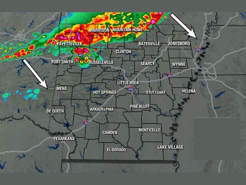
ARKANSAS — A noisy and potentially strong thunderstorm complex is expected to move southeast into Arkansas very late Thursday night and into early Friday morning, with the Arkansas Weather Network Futurecast showing significant storm activity across the northwestern portion of the state by 6:30 AM Friday.
Strong winds, hail, and a tornado warning or two are all possible during the morning commute window, making Friday morning a particularly dangerous time for travelers across Fayetteville, Fort Smith, Harrison, Mountain Home, Russellville, and surrounding communities. A brief afternoon break is expected before more storms develop Friday evening.
Morning Commute Storm Window Hits Northwest Arkansas at 6:30 AM
The Arkansas Futurecast for Friday at 6:30 AM shows a strong and well-organized thunderstorm complex pushing southeast across northwest Arkansas, with the most intense radar returns concentrated across the Fayetteville, Fort Smith, Harrison, Mountain Home, and Russellville corridor during the early morning hours.
The timing is particularly concerning as it places the heaviest storm activity directly over heavily traveled commute routes during the peak morning travel window. Residents across northwest and north-central Arkansas should consider delaying travel if possible during the 6 to 8 AM window Friday and monitor conditions closely before heading out.
Tornado Warnings Possible Along With Winds and Hail
Beyond the general storm threat, forecasters are specifically flagging the possibility of a tornado warning or two as the complex moves through northwest Arkansas Friday morning. Strong winds and hail will also be possible with the stronger cells within the complex during the morning hours.
The combination of potential tornado warnings, strong winds, and hail during the morning commute makes this a setup that warrants serious attention from residents across the affected corridor. Have shelter plans identified at both home and workplace locations before Friday morning arrives.
Brief Afternoon Break Before Evening Storms Return
Friday will not be a continuously stormy day across Arkansas. A break in the weather is expected during the middle part of the afternoon, giving residents a window of calmer conditions before the next round of storm development begins Friday evening. Those evening storms could also be strong to severe, extending the overall threat period well beyond the morning commute window.
Extended Severe Weather Pattern Continues Saturday Through Tuesday
Friday’s multi-round severe weather event is just the beginning of an extended active pattern for Arkansas. Forecasters are expecting some form of legitimate severe weather risk on Saturday, Sunday, Monday, and Tuesday, with the possibility that risks could continue into the middle of next week as well. Residents across the state should treat the coming week as an extended preparedness period rather than a single-event threat. Stay with NapervilleLocal.com for the latest weather updates and local forecast coverage.

I’ve lived in Naperville long enough to see how quickly our community changes — from new developments downtown to sudden shifts in our Midwest weather. Reporting on Naperville news and daily forecasts gives me the chance to keep neighbors informed about what really matters. My goal is simple: deliver clear, timely updates so you always know what’s happening in our city and what to expect from the skies above.