
Damaging Winds, Large Hail, and Tornadoes Targeting Dallas, Little Rock, and Springfield Missouri Friday April 24 as Active Severe Weather Stretch Continues
TEXAS, ARKANSAS, AND MISSOURI — Severe weather will continue into Friday April 24, 2026 across a broad corridor covering Dallas, Little Rock, and Springfield Missouri, as another active stretch of severe weather pushes through the south-central United States.
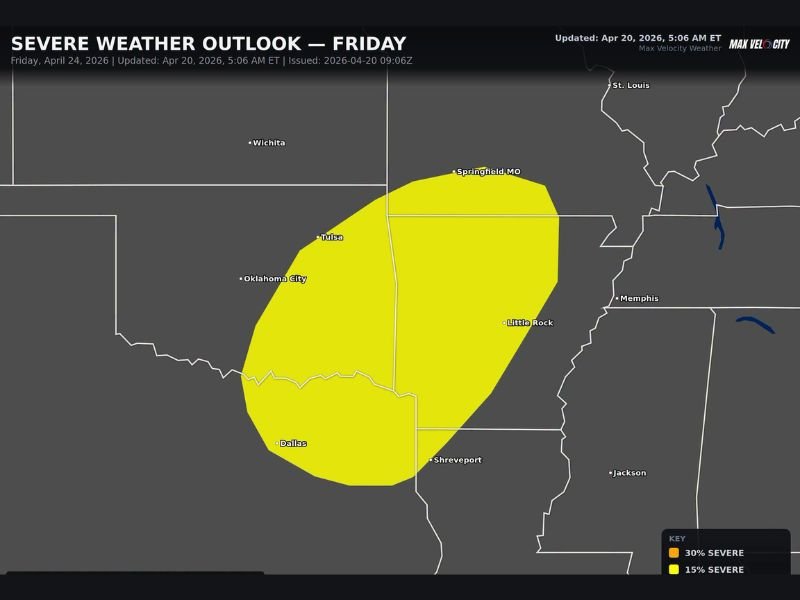
The Max Velocity Weather Severe Weather Outlook for Friday shows a 15% severe weather probability zone blanketing a wide swath from Dallas and Oklahoma City northeastward through Little Rock and up to Springfield Missouri, with damaging winds, large hail, and a couple of tornadoes all possible across the outlined risk area.
Risk Zone Covers Dallas Through Springfield Missouri
The Friday severe weather outlook zone covers an expansive corridor across three states. Dallas sits on the southern edge of the risk area, with the zone extending northeastward through Tulsa, Oklahoma City, Little Rock, Shreveport, and reaching as far north as Springfield Missouri near the top of the outlined area.
Memphis sits just east of the primary risk zone while Wichita and St. Louis fall outside the outlined area to the north and east respectively. Residents across the core of the risk corridor including all communities between Dallas and Springfield Missouri should treat Friday’s threat seriously and have preparedness measures in place ahead of storm development.
Damaging Winds, Large Hail, and Tornadoes All Possible
Three distinct severe weather hazards are associated with Friday’s outlook. Damaging wind gusts represent a widespread threat across the entire risk corridor, capable of downing trees and power lines across portions of Texas, Oklahoma, Arkansas, and Missouri.
Large hail is the second primary hazard, with the potential for significant hail sizes accompanying the strongest storm cells that develop during the Friday window. Perhaps most notably, a couple of tornadoes are also considered possible within the risk zone, adding a rotating storm component to what is already a multi-hazard severe weather setup for the day.
Another Active Stretch of Severe Weather Underway
Friday’s threat is part of a broader and ongoing active severe weather pattern that is once again revving up across the south-central United States. After the brief break in severe weather activity over the weekend, the pattern has wasted little time returning to an active state across the Plains and mid-South corridor.
The combination of Thursday’s significant severe weather threat across Iowa and Missouri followed immediately by Friday’s Dallas to Springfield corridor risk means residents across a large portion of the central US are facing back-to-back days of severe weather concerns through the latter half of this week.
Stay Alert Through Friday and Monitor Updates
With the Friday outlook issued as of April 20, 2026, additional refinements to the risk area, timing, and specific hazard probabilities are expected as the week progresses. Residents across Dallas, Little Rock, Springfield Missouri, and the broader outlined corridor should monitor updated forecasts daily and ensure all severe weather preparedness steps are completed before Friday arrives. Stay with NapervilleLocal.com for the latest weather updates and local forecast coverage.

I’ve lived in Naperville long enough to see how quickly our community changes — from new developments downtown to sudden shifts in our Midwest weather. Reporting on Naperville news and daily forecasts gives me the chance to keep neighbors informed about what really matters. My goal is simple: deliver clear, timely updates so you always know what’s happening in our city and what to expect from the skies above.