
Strong to Severe Storms Possible Across Arkansas, Oklahoma, and North Texas Friday as Daytime Risk Develops With Heavy Rain and Scattered Storms
ARKANSAS, OKLAHOMA, AND NORTH TEXAS — A strong to severe storm threat is being watched for Friday across a broad corridor covering Arkansas, Oklahoma, and North Texas, with the risk currently appearing to be a daytime event rather than overnight.
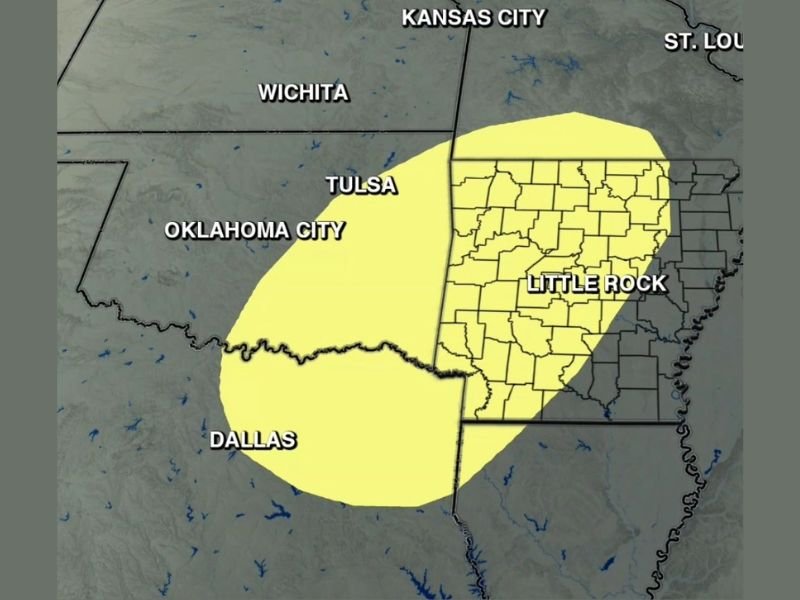
The Arkansas Weather Network Severe Outlook for Friday places a Low to Medium risk zone centered across Little Rock and the surrounding region, extending westward through Tulsa, Oklahoma City, and into the Dallas corridor. Pockets of heavy rain will also be possible alongside the scattered storm activity throughout the day.
Daytime Risk Covers Little Rock, Tulsa, and Dallas Corridor
The Friday severe outlook zone is centered across Arkansas with Little Rock sitting near the core of the risk area. The threat extends westward through Tulsa and Oklahoma City and southward into the Dallas metro area, while the northern edge of the risk zone reaches toward Kansas City and St. Louis.
The daytime timing of Friday’s threat is a notable characteristic of this setup, as afternoon severe weather events typically provide more warning lead time compared to overnight systems. Residents across the outlined zone should remain weather aware through the daylight hours Friday and not assume the threat is limited to the evening hours.
Low to Medium Risk Across the Outlined Zone
The severity designation for Friday currently sits at the Low to Medium level across the primary risk area, indicating that while strong to severe storms are possible, a widespread outbreak is not the expectation at this stage of the forecast. Confidence in specific details will increase as Friday draws closer and additional model data becomes available through the week.
The combination of a Low to Medium risk with a daytime timing suggests an environment that could support isolated to scattered severe storms rather than a large organized squall line, though forecasters will be monitoring trends closely for any upgrades.
Heavy Rain Pockets Add to Friday’s Concerns
Beyond the severe storm threat, pockets of heavy rainfall will be possible with the scattered storm activity across the risk zone on Friday. The heavy rain potential adds a flooding dimension to Friday’s forecast across portions of Arkansas and surrounding states, particularly in areas that have already seen meaningful rainfall during the recent active weather period.
Residents across Little Rock, the Arkansas River Valley, and surrounding low-lying areas should be aware of the dual threat of both severe storm impacts and localized heavy rainfall through Friday.
More Updates Expected as Friday Approaches
Forecasters are clear that additional updates will be issued as the week progresses and the Friday setup comes into sharper focus. The current outlook represents an early look at the potential, and specifics including storm timing, exact risk area boundaries, and primary hazards will be refined significantly over the coming days.
Residents across Arkansas, Oklahoma, and North Texas should stay tuned to updated forecasts through the week and have preparedness measures in place before Friday arrives. Stay with NapervilleLocal.com for the latest weather updates and local forecast coverage.

I’ve lived in Naperville long enough to see how quickly our community changes — from new developments downtown to sudden shifts in our Midwest weather. Reporting on Naperville news and daily forecasts gives me the chance to keep neighbors informed about what really matters. My goal is simple: deliver clear, timely updates so you always know what’s happening in our city and what to expect from the skies above.