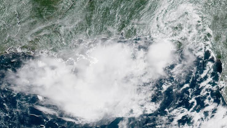
A tropical system could form in the southwestern Gulf this week, and the National Hurricane Center raised its odds again Monday.
In its outlook issued Oct. 5, the NHC gave a trough of low pressure over the southwestern Gulf of America a 60% chance of developing within 48 hours and an 80% chance within seven days. On Sunday evening those numbers were 0% and 40%.
If it reaches tropical storm strength, it would be named Isaias, the next name on the 2026 Atlantic list.
Rain is already the problem
The system hasn’t formed yet. The flooding along the northern Gulf Coast has started anyway, and it is not connected to it.
A slow-moving front and tropical moisture dumped heavy rain on coastal Alabama and the Florida Panhandle over the weekend. The National Weather Service issued a flash flood warning for Santa Rosa County, Florida, at 3:32 a.m. Sunday. Flood watches stayed in effect for parts of coastal Alabama and northwest Florida.
The NWS forecast an additional 2 to 5 inches in the hardest-hit areas, with isolated totals of 6 to 10 inches. Rain rates of 2 to 3 inches an hour were reported at one point Sunday, according to a local report on the radar outage.
That outage is its own story. Five radars covering the region went dark, according to Hoodline: Mobile (KMOB), Eglin Air Force Base (KEVX), Fort Rucker (KEOX), Tallahassee (KTLH) and Moody Air Force Base (KVAX). The Mobile NWS office said it had been dealing with the problem since Saturday and that the Mobile and Eglin radars would stay offline until further notice. The cause was not given in the report. NOAA Weather Radio kept working, and a radar in Louisiana came back online Sunday.
If you live along the I-10 corridor, don’t count on radar apps alone for the next few days. Keep a weather radio or the local NWS alerts turned on.
How much more rain
Forecasters are not in full agreement on totals, which is normal this far out.
- AccuWeather: 4 to 8 inches across northern Florida where the heaviest bands set up, with a local “StormMax” of 14 inches. Panama City to Orlando, 2 to 4 inches.
- WUSF (Florida public radio), citing NWS guidance: 5 to 7 inches around Jacksonville, possibly more than 10 in isolated spots, and about 5 more inches in the Panhandle this week. The Panhandle sits under a slight risk (15%) of flash flooding.
The front is expected to stall near Lake Okeechobee by Wednesday or Thursday, which would push heavier rain into South Florida.
“By later this week, a cluster of showers and thunderstorms in the southern Gulf and Bay of Campeche may organize into a tropical rainstorm,” AccuWeather senior meteorologist Dan Pydynowski said. “This would add to the flood threat from southern Georgia and the Florida Panhandle westward along Interstate 10.”
What’s still unknown
Quite a lot. The NHC has described conditions as only marginally favorable, and models disagree on strength and track. Wind shear could keep it disorganized.
CNN reported Monday that a storm is likely to form in the Gulf this week despite El Niño, a climate pattern that usually adds wind shear and holds Atlantic activity down.
The Eyewall, a widely read forecasting newsletter, argued this week that the setup deserves attention. It pointed to record-warm Gulf water and a track generally north or northeast toward Louisiana and Florida rather than Texas, and said the main threat is a heavy rain event along the Gulf Coast and Florida. That is one forecaster’s read, not an official forecast. The 2026 Atlantic season has been unusually quiet so far.
Nothing official yet on watches or warnings for the coast. Those would come from the NHC if a depression or storm takes shape.
Pacific side is busy too
The same NHC outlook is tracking Hurricane Rachel well west-southwest of the southern Baja California Peninsula, plus a second area near the Gulf of Tehuantepec with 60% odds of forming in 48 hours and 90% over seven days.
Southern California is baking
Separately, more than 37 million people were under heat alerts across California as of Sunday, ABC News reported. Temperatures ran about 20 degrees above normal. Anaheim and San Diego reached 105, Santa Ana hit 107, and Vista hit 108, tying its all-time record from June 30, 1985. Excessive heat warnings were set to run through 8 p.m. Thursday, and fire risk is up.
What to do now
- Never drive through flooded roads. Turn around.
- Check that your phone’s emergency alerts are on.
- Gulf Coast residents should look over their hurricane plan this week, even though nothing has formed.
- Next full NHC outlook comes out at regular times each day at nhc.noaa.gov.
This is a developing story and numbers may change. Check the National Hurricane Center and your local National Weather Service office for the latest.