
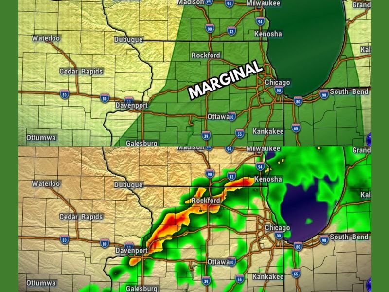
Gusty Winds and Large Hail Possible Across Illinois and Wisconsin Including Rockford Chicago Kenosha and Madison Under Marginal Risk This Afternoon Between 1PM and 5PM
ILLINOIS — A Marginal Risk for severe weather remains in place across a large portion of northern Illinois and southern Wisconsin this afternoon and early evening, with gusty winds and large hail as the primary threats should any storms manage to become severe. Mostly cloudy skies and dry air are significantly limiting the overall severe weather potential, but the threat has not been eliminated entirely. Model guidance currently points to a storm window running from 1:00 PM through 5:00 PM, though that timing could shift an hour or two in either direction.
Cloudy Skies and Dry Air Keep Severe Weather Potential on the Low to Very Low Side
The biggest limiting factor working against storm development today is the combination of mostly cloudy skies and dry air sitting across the region. Without sufficient sunshine to help destabilize the atmosphere and with moisture values running below what is typically needed for a robust severe weather setup, the ceiling for storm intensity remains suppressed through the afternoon hours.
That said, the Marginal Risk designation confirms that showers and storms are a decent to good bet this afternoon and early evening. The question is not whether storms will develop but whether any of them can tap into just enough energy to briefly reach severe criteria.
Storm Window Runs From 1PM to 5PM Across Rockford Chicago Kenosha and Ottawa Corridor
High-resolution model guidance is pointing to a primary storm window between 1:00 PM and 5:00 PM across the Marginal Risk zone, covering communities including Rockford, Chicago, Kenosha, Ottawa, and Kankakee. The precisioncast radar imagery shows storm activity pushing through the region during the 2:00 PM through 4:00 PM timeframe before beginning to exit the Chicago metro area by 5:00 PM.
Timing on these systems can always shift, and an hour or two of variance in either direction is possible as the afternoon unfolds. Staying connected to real-time radar and alert notifications during this window is the most important step for anyone in the outlined zone.
Gusty Winds and Large Hail Remain the Threats if Any Storm Reaches Severe Criteria
Should a storm manage to overcome the limiting atmospheric factors and reach severe criteria, gusty winds and large hail are the two hazards to watch for across the Marginal Risk area. These threats are most likely during the peak of the storm window between 2:00 PM and 4:00 PM based on current model projections.
Anyone with outdoor plans this afternoon across northern Illinois and southern Wisconsin should have a weather alert method active and be ready to move indoors quickly if warnings are issued. The overall threat is low to very low, but gusty winds and large hail can cause real damage in a short period of time even in a marginal severe weather setup. Stay with NapervilleLocal.com for the latest weather updates and local forecast coverage.

I’ve lived in Naperville long enough to see how quickly our community changes — from new developments downtown to sudden shifts in our Midwest weather. Reporting on Naperville news and daily forecasts gives me the chance to keep neighbors informed about what really matters. My goal is simple: deliver clear, timely updates so you always know what’s happening in our city and what to expect from the skies above.