
Heavy Weekend Rainfall Soaks Houston Metro With Ongoing Rain Chances Through Midweek Before Warm and Humid Weekend Returns
HOUSTON, TEXAS — Widespread showers delivered significant rainfall across the Houston metro area this past weekend, with radar estimated totals showing heavy accumulations across a broad swath of the region as of April 19, 2026. The wet pattern is not finished yet, with ongoing rain chances expected to continue through the middle of this week before a warming trend develops heading into the weekend. The upcoming weekend looks to be fairly humid as temperatures climb back upward across the Gulf Coast region.
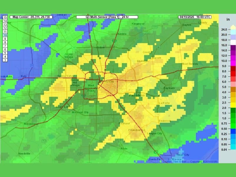
Radar Shows Heavy Rainfall Totals Across Houston Metro
The Q3 Multi-Sensor rainfall map valid through April 19, 2026 shows an impressive and widespread rainfall footprint across the Houston metro area from the weekend storm activity. The heaviest totals are concentrated across the core of Houston and surrounding inner suburbs, with orange and yellow shading indicating rainfall totals in the 5 to 9 inch range across portions of the city including West University Place, Bunker Hill Village, Spring Valley, and surrounding neighborhoods.
Areas including Aldine, Humble, Pasadena, Baytown, Pearland, Friendswood, and League City also picked up meaningful totals in the 3 to 6 inch range, while outer communities including Katy, Missouri City, Sugar Land, and Crosby recorded lighter but still significant accumulations of 1 to 3 inches across the broader metro footprint.
Rain Chances Continue Through Middle of the Week
Following the heavy weekend rainfall, the Houston region will not get an immediate break from the wet pattern. Ongoing rain chances are expected to persist through the middle of this week, keeping soggy conditions across much of the metro area through at least Wednesday or Thursday.
Residents dealing with saturated yards, flooded low-lying areas, or drainage issues from the weekend rainfall should be aware that additional rain through midweek could compound those conditions before any meaningful drying trend develops across the region.
Warming Trend and Humidity Build Heading Into the Weekend
After the midweek rain chances wind down, a warming trend will develop heading into the weekend. The upcoming weekend is expected to be noticeably warmer than the current week, with humidity levels also climbing as Gulf moisture returns to the region following the passage of the frontal system responsible for the weekend rainfall.
The combination of warming temperatures and increasing humidity heading into the weekend will make conditions feel characteristically sticky across the Houston metro, consistent with the Gulf Coast’s typical late April pattern as the region transitions further into spring and toward the summer humidity season. Stay with NapervilleLocal.com for the latest weather updates and local forecast coverage.

I’ve lived in Naperville long enough to see how quickly our community changes — from new developments downtown to sudden shifts in our Midwest weather. Reporting on Naperville news and daily forecasts gives me the chance to keep neighbors informed about what really matters. My goal is simple: deliver clear, timely updates so you always know what’s happening in our city and what to expect from the skies above.