
Strong to Severe Storms Targeting Dallas Northeast Texas Friday and Saturday After 5 PM With Wind, Hail Risk as Dryline and Oklahoma Front Combine
NORTH TEXAS — Strong to severe storms are being watched for Friday and Saturday across North Texas as a dryline pushing in from West Texas and a front slowly sagging southward from Oklahoma combine to create an increasingly unstable atmosphere during the second half of both days.
The Storm Prediction Center has already highlighted a Slight Risk for areas northeast of Dallas for Friday, with mainly wind and hail as the primary threats after 5 PM. Saturday’s setup may actually be more favorable than Friday as the dryline pushes further east and the front potentially stalls and retreats northward.
Tuesday Brings Rain Before Pattern Dries Out Into Late Week
Before the weekend storm threat arrives, a 50% chance of plain rain will spread into the area on Tuesday, delivering an estimated 0.25 to 0.75 inches of rainfall across the region. This midweek rain will be followed by a drying and warming trend through the latter part of the week, with temperatures rebounding into the upper 80s by Friday ahead of the approaching front from Oklahoma.
The warming and drying trend through Thursday will help load the atmosphere with instability ahead of the Friday afternoon and evening storm window.
Friday Storm Window Opens After 5 PM Northeast of Dallas
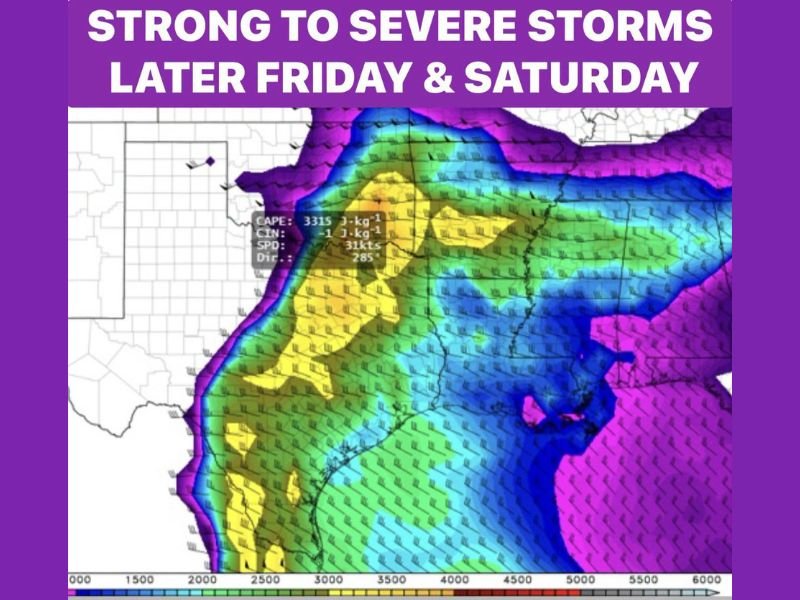
Friday’s severe weather setup is driven by the dryline moving in from West Texas interacting with the southward-sagging front and increasing atmospheric instability. CAPE values shown on the model data are impressive, reaching 3315 J/kg across portions of the region, providing significant fuel for storm development during the evening hours.
The Storm Prediction Center’s Slight Risk designation for areas northeast of Dallas highlights wind and hail as the primary threats Friday evening. Storms are not expected to fire until after 5 PM, with the threat continuing into the evening hours as the dryline and frontal interaction intensifies across the region.
Saturday Could Bring a More Active Setup Than Friday
Saturday’s setup is currently being viewed as potentially more favorable for severe storms than Friday. The front may stall nearby and begin retreating northward, while the dryline is expected to be positioned further east, creating an even better alignment of ingredients for organized storm development after 5 PM Saturday evening.
With the setup still five to six days away at the time of this outlook, confidence in specific details remains limited and forecasters will be closely watching trends through the end of the week before issuing more refined guidance on Saturday’s threat potential.
Heart of Severe Storm Season Runs Through Mid-June
Forecasters note that the region is now firmly in the heart of severe storm season, which runs through the middle of June across North Texas. The Friday and Saturday setups are consistent with the type of dryline-driven severe weather events that are typical during this period, and residents across the Dallas northeast corridor should remain weather aware through the upcoming weekend. Stay with NapervilleLocal.com for the latest weather updates and local forecast coverage.

I’ve lived in Naperville long enough to see how quickly our community changes — from new developments downtown to sudden shifts in our Midwest weather. Reporting on Naperville news and daily forecasts gives me the chance to keep neighbors informed about what really matters. My goal is simple: deliver clear, timely updates so you always know what’s happening in our city and what to expect from the skies above.