
Large Area Severe Weather With Strong Tornado, Very Large Hail, and 75 MPH Wind Gusts Targeting Central Kansas, Nebraska, and Southwest South Dakota Saturday May 30
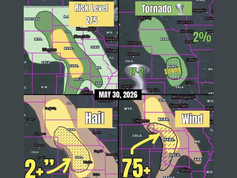
CENTRAL PLAINS — A large and dangerous severe weather setup is unfolding across the central and northern Plains on Saturday, May 30, 2026, with a Risk Level 2 out of 5 covering a broad corridor from southwest South Dakota through Nebraska and into central Kansas and northern Oklahoma.
Central Kansas carries the highest tornado concern where a strong EF-2 or greater tornado is possible aided by extra wind shear from outflow boundaries left over by overnight storms, while very large hail of 2 inches or greater and destructive winds of 75 mph or more are additional headline hazards across the broader risk zone.
Central Kansas Carrying the Strongest Tornado Risk With EF-2 Potential Saturday
Central Kansas is the primary area of concern for today’s tornado threat, where the combination of favorable shear, instability, and residual outflow boundaries from overnight storm activity create an enhanced environment for strong tornado development. The tornado risk zone shows a strong probability designation specifically over central Kansas with a 2 percent broader tornado probability extending across the wider corridor from Nebraska through northern Oklahoma.
Any tornado developing across central Kansas today carries potential for EF-2 intensity, making this a life-threatening severe weather situation for communities across the affected zone. Residents should have a shelter plan identified well before afternoon storm development begins.
Very Large Hail Over 2 Inches and Destructive Winds to 75 MPH Across Nebraska and South Dakota
The hail threat extends across a broad hatched zone through Nebraska and into Kansas where 2-plus inch hail is possible with the strongest supercells. The destructive wind threat corridor covers Kansas and southern Nebraska where gusts of 75 mph or greater are possible, capable of causing significant structural damage and dangerous travel conditions.
Southwest South Dakota through Nebraska and into far northern Oklahoma all fall within the broader severe weather risk area with very large hail and damaging winds as the primary hazards across the northern portions of the zone.
Risk Level 2 Zone Demands Full Severe Weather Preparedness Across the Central Plains Today
All residents across the Risk Level 2 corridor from South Dakota through Kansas should treat Saturday as a serious and potentially life-threatening severe weather day. Staying connected to local warnings and having a shelter plan ready before storms develop is the most critical action for everyone in the risk zone. Stay with NapervilleLocal.com for the latest weather updates and local forecast coverage.

I’ve lived in Naperville long enough to see how quickly our community changes — from new developments downtown to sudden shifts in our Midwest weather. Reporting on Naperville news and daily forecasts gives me the chance to keep neighbors informed about what really matters. My goal is simple: deliver clear, timely updates so you always know what’s happening in our city and what to expect from the skies above.