
Scattered Severe Storms Possible Wednesday Across Midwest and Ohio Valley With Damaging Winds and Hail as Primary Threats and Tornado Chance Under 2%
MIDWEST AND OHIO VALLEY — Scattered severe storms are possible today Wednesday April 22, 2026 across a broad corridor of the Midwest and Ohio Valley, though severe weather chances remain on the lower end overall.
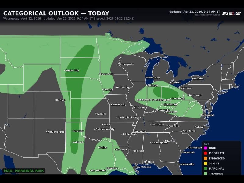
The Categorical Outlook issued by Max Velocity Weather shows a Marginal Risk as the maximum risk level for today, covering a wide swath from the northern Plains through the Great Lakes and into the Ohio Valley and mid-South. Damaging winds and hail are the primary threats with any storms that develop, while the tornado probability remains less than 2% across the entire outlined area.
Marginal Risk Covers a Wide Multi-State Corridor
The today’s Categorical Outlook shows a Marginal Risk zone blanketing an expansive area across multiple states. The risk zone stretches from the Dakotas and Nebraska northeastward through Minneapolis, Milwaukee, Chicago, Detroit, and Cleveland before extending southward through Indianapolis, Columbus, Cincinnati, Louisville, and into the Tennessee Valley corridor including Nashville, Knoxville, Memphis, and Birmingham.
A broader Thunder zone extends further westward through Kansas, Oklahoma, and into Texas, indicating that general thunderstorm activity is possible across an even larger geographic footprint beyond the primary Marginal Risk area today.
Damaging Winds and Hail Are the Primary Concerns
Two hazards stand out with today’s scattered severe storm potential. Damaging wind gusts represent the most widespread threat across the Marginal Risk zone, capable of downing tree branches and causing isolated property damage with any stronger cells that develop during the afternoon and evening hours.
Large hail is the second primary concern, though hail sizes are not expected to reach the extreme levels seen during recent outbreak events across the region. Any storms that do reach severe criteria today will likely produce hail and gusty winds as the dominant hazards rather than organized tornado activity.
Tornado Chance Remains Very Low at Under 2%
One reassuring aspect of today’s severe weather setup is the extremely low tornado probability. Forecasters have pegged the tornado chance at less than 2% across the entire risk area, reflecting the marginal atmospheric setup and lack of the organized wind shear and instability needed to support significant rotating storm development today.
This places today’s threat in a much lower category compared to the significant tornado outbreaks that have dominated the region throughout April 2026, offering some relief to residents who have been on repeated high alert for rotating storms in recent weeks.
Scattered Nature Means Not Everyone Will See Storms
With today’s outlook maxing out at the Marginal Risk level and storm coverage expected to be scattered rather than widespread, the majority of residents across the outlined zone will likely not experience any severe weather impacts today. The storms that do develop will be isolated in nature, meaning significant geographic variability in impacts even across small areas within the risk zone.
Residents should remain weather aware through the afternoon and evening but can approach today’s threat with considerably less urgency than the significant severe weather events that have unfolded across the region in recent days. Stay with NapervilleLocal.com for the latest weather updates and local forecast coverage.

I’ve lived in Naperville long enough to see how quickly our community changes — from new developments downtown to sudden shifts in our Midwest weather. Reporting on Naperville news and daily forecasts gives me the chance to keep neighbors informed about what really matters. My goal is simple: deliver clear, timely updates so you always know what’s happening in our city and what to expect from the skies above.