
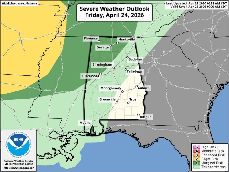
Marginal Risk Severe Storms Targeting Northwest Alabama Including Florence and Huntsville Friday Night Before Unsettled Pattern Continues Through the Weekend
ALABAMA — Alabama is largely dry today and tomorrow with afternoon highs in the 80 to 84 degree range, but the pattern turns active starting Friday night when showers and thunderstorms move in across the state. The SPC has defined a low end Marginal Risk of severe thunderstorms specifically for Northwest Alabama on Friday night, where a few storms could produce strong gusty winds. The weekend then brings additional rain chances Saturday and Sunday before an unsettled pattern continues into next week across the Deep South.
Marginal Risk Targets Northwest Alabama Friday Night
The Severe Weather Outlook for Friday April 24 shows a Marginal Risk zone covering Northwest Alabama including Florence, Huntsville, Decatur, and Gadsden. The overall severe threat is characterized as low end, with strong gusty winds being the primary concern with any storms that develop during the Friday night window.
Birmingham, Tuscaloosa, and communities further south fall outside the primary Marginal Risk zone, though scattered storm activity will still be possible across broader portions of the state as the frontal system moves through Friday night.
Saturday Brings Morning Rain With Afternoon Lingering Showers
Saturday’s weather pattern keeps clouds and rain in the picture across Alabama, with the highest coverage of rainfall expected during the morning hours. A few lingering afternoon showers will persist into the second half of the day, but widespread storm activity is not anticipated for the afternoon period.
Skies will remain mostly cloudy throughout Saturday with highs in the low 80s, making for a grey and periodically wet day across much of the state. No significant severe weather concerns are associated with Saturday’s rain activity.
Sunday Stays Relatively Dry With Isolated Southern Showers
Sunday offers a modest improvement with relatively dry conditions expected across most of Alabama. A few isolated showers are possible mainly over the southern half of the state, while some breaks of sun are anticipated at times. Highs will reach the low to mid 80s on Sunday, providing a brief taste of pleasant weather before the pattern turns unsettled again heading into next week.
Unsettled Pattern Continues Into Next Week
An unstable air mass will remain firmly in place across the Deep South for most of next week, keeping the threat of showers and storms in the forecast across multiple days. The SPC has scaled back Monday’s severe weather risk to a smaller area of Northwest Alabama, with the European model suggesting most of Monday’s rain and storms will stay west of the state keeping Alabama mostly dry during the day.
Storms are then expected to move in late Monday night into Tuesday, with the potential for a severe weather threat on Tuesday still to be determined as the forecast period approaches. Stay with NapervilleLocal.com for the latest weather updates and local forecast coverage.

I’ve lived in Naperville long enough to see how quickly our community changes — from new developments downtown to sudden shifts in our Midwest weather. Reporting on Naperville news and daily forecasts gives me the chance to keep neighbors informed about what really matters. My goal is simple: deliver clear, timely updates so you always know what’s happening in our city and what to expect from the skies above.