
Northeast Ohio Including Cleveland and Akron Under Moderate Risk 3/5 for Severe Weather Wednesday 2–9 PM With 75 MPH Winds, Large Hail, and Tornado Threat
NORTHEAST OHIO — A Moderate Risk, Level 3 out of 5, has been officially issued for parts of Northeast Ohio today as model guidance has consistently locked onto a cluster of severe storms expected to develop between 2 PM and 9 PM. This marks a major upgrade to the forecast and signals that widespread severe weather is expected across the affected zone. The situation has the potential to escalate quickly once storms begin to mature.
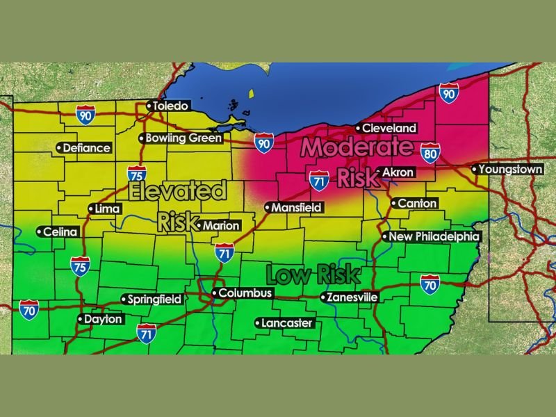
Moderate Risk Zone Covers Cleveland, Akron, and Surrounding Areas
The Moderate Risk designation covers a significant portion of Northeast Ohio, including Cleveland, Akron, Canton, Youngstown, and New Philadelphia. This is not a commonly issued risk level and indicates that widespread severe weather impacts are expected rather than just possible.
Areas to the west, including Toledo, Bowling Green, Lima, Marion, and Mansfield, fall under an Elevated Risk zone. Central and southern portions of Ohio including Columbus, Zanesville, Springfield, Dayton, and Lancaster carry a Low Risk designation for today’s storm system.
Primary Threats Include 75 MPH Winds, Half-Dollar Hail, and Tornadoes
Three serious hazards are in play for Northeast Ohio this afternoon and evening. Wind gusts up to 75 MPH represent the most widespread and damaging threat, capable of downing trees, power lines, and causing structural damage across a wide area.
Half-dollar-size hail is also expected with the stronger storms that develop, posing a significant risk to vehicles, rooftops, and anyone caught outdoors. Additionally, a low but non-zero tornado risk exists, with strong wind shear in place supporting the potential for a quick spin-up tornado during the most active storm window.
Why Confidence Is Increasing Heading Into the Afternoon
Two key atmospheric ingredients are coming together to fuel today’s severe weather setup. CAPE values near or above 2,000 J/kg represent some of the strongest atmospheric instability seen this year across the region, providing significant energy for storm development and intensification.
Strong wind shear is the second critical ingredient, supporting long-lived storms, organized clusters, and the potential for rotating updrafts. Together these two factors create a setup that forecasters warn can escalate very rapidly once storms begin to mature during the afternoon hours.
Understanding the Risk Scale
To put today’s Moderate Risk designation in proper context, forecasters use a five-tier system to communicate severe weather potential. A Low Risk indicates scattered severe impacts or low confidence, while Elevated means thunderstorms are likely with several possibly becoming severe.
Moderate means widespread severe weather is expected across the zone. High is reserved for high-end events with widespread destructive potential, and Extreme — the rarest designation — is reserved for tornado outbreaks or destructive derechos and is sometimes not issued for an entire season.
Take Action Now Before Storms Arrive
Residents across Northeast Ohio and the broader Elevated Risk zone are urged to finalize all preparedness steps before 2 PM today. Have multiple ways to receive weather alerts, know your nearest shelter location, and avoid unnecessary travel during the 2 PM to 9 PM window.
Do not wait for a warning to be issued for your specific location before taking action. This is a setup that can produce damaging conditions with very little additional warning once storms organize and mature. Stay with NapervilleLocal.com for the latest weather updates and local forecast coverage.

I’ve lived in Naperville long enough to see how quickly our community changes — from new developments downtown to sudden shifts in our Midwest weather. Reporting on Naperville news and daily forecasts gives me the chance to keep neighbors informed about what really matters. My goal is simple: deliver clear, timely updates so you always know what’s happening in our city and what to expect from the skies above.