
Illinois, Missouri, and Arkansas Face Major Severe Weather Outbreak Friday April 17 With Tornado Risk as Strong Cold Front Separates 90° Heat From Arctic 30s and 40s
MIDWEST — A significant severe weather outbreak is looking increasingly likely across the Midwest this Friday, April 17, 2026, as a strong cold front pushes eastward and slams into dangerously warm air sitting across the region. The clash between 90°F heat and incoming air temperatures in the 30s and 40s from the northwest is expected to fuel an explosive storm environment capable of producing tornadoes, damaging winds, and large hail.
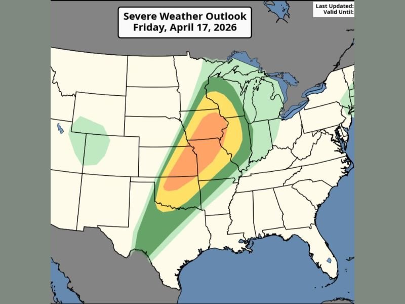
Friday Shapes Up as the Most Dangerous Day of the Week
The Severe Weather Outlook for Friday places a Moderate Risk zone centered across Illinois, Missouri, and Arkansas, with an Enhanced Risk surrounding that core area extending into neighboring states. The highest concentration of storm energy is focused across the central Plains and Mississippi Valley corridor, where the temperature contrast between air masses will be most dramatic during the afternoon and evening hours.
Surrounding the Enhanced zone, a broad Slight and Marginal Risk area stretches from the Great Lakes southward through the Gulf Coast region, indicating that the severe weather footprint on Friday will be widespread and far-reaching.
Strong Cold Front Triggers the Outbreak
The driving force behind Friday’s severe weather threat is a powerful cold front sweeping in from the northwest. This front will act as the primary trigger for storm development, providing the lift needed to rapidly ignite thunderstorms across a very unstable air mass.
The front will sharply separate the 90°F heat entrenched across the region from much cooler air in the 30s and 40s moving in behind it. That kind of dramatic temperature gradient in a short distance is a classic recipe for explosive and long-lived severe storm development.
Tornado Risk Is a Significant Concern Friday
Among the threats associated with Friday’s outbreak, tornadoes stand out as a particularly serious concern. The combination of extreme instability from the 90°F heat, strong wind shear associated with the cold front, and favorable atmospheric dynamics creates an environment capable of supporting organized and long-tracked tornado activity.
Residents across Illinois, Missouri, Arkansas, and surrounding states within the Moderate and Enhanced Risk zones should have a tornado safety plan finalized well before Friday afternoon arrives.
Southeast Stays Hot and Mostly Dry Through the Weekend
While the Midwest corridor braces for the severe weather outbreak, the Southeast region will remain largely out of the storm picture through the weekend. Hot and mostly dry conditions are expected to persist, with the best and only chance for rain arriving Sunday as the front finally pushes through the region.
That Sunday rain will bring a few showers and isolated thunderstorms, though nothing widespread is anticipated. Cooler air will then begin to settle into the Southeast early next week following the frontal passage.
Prepare Well Ahead of Friday’s Storm Window
Given the severity of what is shaping up for Friday, forecasters are urging residents across the Midwest and central Plains to complete all severe weather preparations before the storm window opens. Identify shelter locations, charge devices, and have multiple ways to receive weather alerts active and ready.
This is not a system to monitor casually. The ingredients are in place for a significant and dangerous outbreak, and conditions could escalate rapidly once storms initiate Friday afternoon. Stay with NapervilleLocal.com for the latest weather updates and local forecast coverage.

I’ve lived in Naperville long enough to see how quickly our community changes — from new developments downtown to sudden shifts in our Midwest weather. Reporting on Naperville news and daily forecasts gives me the chance to keep neighbors informed about what really matters. My goal is simple: deliver clear, timely updates so you always know what’s happening in our city and what to expect from the skies above.