
Three Impact Days Threatening Alabama This Week With Friday Storms After 5 PM, Monday Night Severe Risk, and 2-3 Inches of Rainfall Expected Statewide
ALABAMA — Three impact weather days are ahead for Alabama this week as a series of storm systems move through the state from Friday through Tuesday. Friday brings the first round of storms after 5 PM with a low severe risk, the weekend stays mostly manageable, and then Monday night into Tuesday morning emerges as the most closely watched period with a risk of severe storms arriving during the overnight hours. Most of North and Central Alabama is forecast to pick up 2 to 3 inches of rainfall through the seven-day period, providing welcome drought relief across the state.
Friday Impact Day — Storms After 5 PM With Gusty Winds
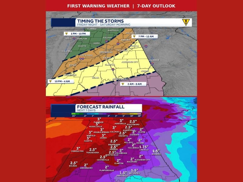
Friday’s storm timeline shows a weakening line pushing through Alabama beginning around 5 PM across the western portions of the state near Tuscaloosa, Fayette, and Hamilton, progressing eastward through Birmingham between 7 PM and midnight and reaching Montgomery and central Alabama between 2 and 8 AM Saturday morning.
The main threat with Friday’s line is gusty winds as the system weakens while crossing into Alabama. The storms will still drop beneficial rainfall across the state despite losing severe punch, with highs reaching the mid-80s through the afternoon ahead of the evening arrival.
Weekend Looks Mostly Manageable for Outdoor Plans
Saturday will see overnight rain and storms ending before skies partially clear and highs climb back near 80 degrees. Isolated afternoon storms are possible but most of Saturday and Sunday look mainly dry across Alabama. Talladega race fans should be able to dodge a storm or two with the bulk of race weekend remaining okay.
Sunday stays mostly dry with 80% of Alabama rain-free and a few isolated showers possible. Low 80s temperatures make for a comfortable late April Sunday across most of the state.
Monday Night Into Tuesday Morning Is the Most Watched Period
The setup that forecasters are watching most carefully is Monday night into Tuesday morning. A risk of severe storms exists during this window, with timing currently pointing to storms arriving Monday night and the bulk of activity occurring before Tuesday sunrise. The overnight timing adds extra concern given that residents will be asleep during the peak threat window.
Confidence in the exact timeline and specific threats for the Monday night into Tuesday morning period remains low and will continue to evolve through the weekend. Residents across Birmingham, Huntsville, and North and Central Alabama should monitor updated forecasts closely heading into next week.
2-3 Inches of Rainfall Expected Across North and Central Alabama
The seven-day forecast rainfall map shows meaningful totals across the state. Florence, Russellville, Winfield, Fayette, Double Springs, and Jasper are all forecast to see around 3 inches through the week, while Huntsville, Scottsboro, Cullman, and Birmingham pick up 2.5 to 3 inches. The widespread 2 to 3 inch totals across North and Central Alabama should result in noticeable improvement on the next drought monitor update for the state. Stay with NapervilleLocal.com for the latest weather updates and local forecast coverage.

I’ve lived in Naperville long enough to see how quickly our community changes — from new developments downtown to sudden shifts in our Midwest weather. Reporting on Naperville news and daily forecasts gives me the chance to keep neighbors informed about what really matters. My goal is simple: deliver clear, timely updates so you always know what’s happening in our city and what to expect from the skies above.