
Scattered Rainfall Chances Across Florida Through Sunday Night With Peninsula Winds Shifting Coverage Toward the East Side and No Washout Expected Through June 1
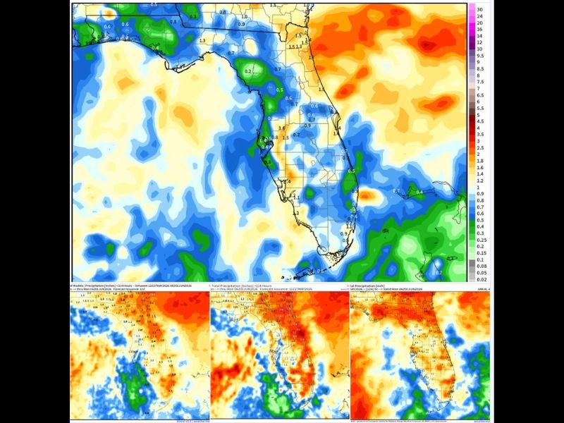
FLORIDA — Scattered rainfall is in the forecast across Florida from now through Sunday night, June 1, 2026, with four major forecast models including the EURO, GFS, WPC, and BLEND all showing rain chances statewide but no washout expected for any portion of the peninsula. Peninsula winds are expected to shift and bring more rainfall coverage toward the east side of the state through the period, while the west coast and interior zones show lighter accumulation totals on most model solutions.
Four Model Consensus Shows Rain Chances Statewide but No Widespread Washout
The blended model output valid through Monday June 1 shows the most widespread rainfall coverage concentrated along the central and southern peninsula, with totals of 0.5 to 1.6 inches depicted across a broad zone from the Tampa Bay area southward through the interior and toward the southern tip. The east coast corridor shows totals reaching 1.4 to 1.5 inches in spots while the northern peninsula and panhandle zones stay considerably drier.
All four models are in general agreement that rain chances will be present across the state through the period, though the GFS and EURO solutions differ notably in placement and intensity of the heaviest totals. The blended solution represents the most balanced forecast across all four model perspectives through Sunday night.
Peninsula Winds Shifting to Bring Heavier Coverage Toward the East Side of Florida
A wind shift across the Florida peninsula will direct more of the rainfall coverage toward the eastern side of the state through the forecast period. The east coast from the Space Coast southward through Miami and the Keys sits within the zones of highest model-depicted accumulation, with the offshore moisture feed supporting elevated rain chances along the Atlantic-facing communities.
West coast communities from Tampa through Naples will see rain chances but generally lighter totals compared to the interior and east coast zones as the wind shift redirects the primary moisture feed eastward through the period.
Rainfall Welcome for Drought Reduction Across Florida Through the Early June Period
The incoming rainfall through Sunday night is welcomed across Florida where drought conditions have been a concern heading into the summer season. While totals are not extreme and no washout is expected, consistent shower coverage through the period should help reduce drought stress and provide meaningful moisture across the peninsula heading into June. Stay with NapervilleLocal.com for the latest weather updates and local forecast coverage.

I’ve lived in Naperville long enough to see how quickly our community changes — from new developments downtown to sudden shifts in our Midwest weather. Reporting on Naperville news and daily forecasts gives me the chance to keep neighbors informed about what really matters. My goal is simple: deliver clear, timely updates so you always know what’s happening in our city and what to expect from the skies above.