
Scattered Thunderstorms With Heavy Downpours Filling In Across Arkansas Including Little Rock, Fort Smith, and Fayetteville Wednesday Afternoon and Evening With Low Severe Risk
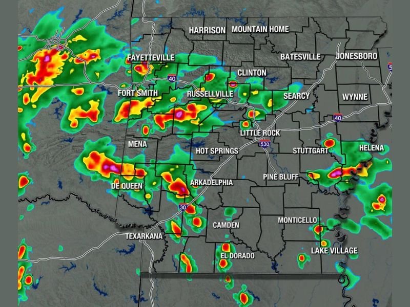
ARKANSAS — Scattered thunderstorm activity is expected to fill in across Arkansas through Wednesday afternoon and evening, May 27, 2026, with the Arkansas Weather Network Futurecast valid at 5PM showing widespread storm coverage developing from the western border eastward through the central and southern portions of the state. While some heavier rain and downpours are possible with this activity, the severe weather risk is described as extremely low, making this primarily a rain and thunder event rather than a significant severe weather threat.
Futurecast Shows Widespread Storm Coverage Filling In From West to East by 5PM Wednesday
The Arkansas Futurecast valid at 5PM Wednesday shows intense red and yellow storm cores developing across the western portions of the state near Fayetteville, Fort Smith, and Mena, with additional moderate to heavy coverage spreading through Russellville, Little Rock, Hot Springs, and Arkadelphia through the afternoon. The storm coverage is expected to expand progressively eastward through the evening hours as the activity fills in across the broader state.
Southern Arkansas communities including De Queen, Camden, El Dorado, and toward Texarkana are also within the developing storm footprint by 5PM, indicating a statewide impact zone for Wednesday’s afternoon and evening activity.
Heavier Rain and Downpours Possible Similar to Tuesday’s Activity Across the State
Much like Tuesday’s storm pattern, Wednesday’s activity carries the potential for locally heavier rainfall and downpours within the most intense cells tracking across the state. These brief heavy rain bursts can produce localized ponding on roadways and reduced visibility for drivers during the peak afternoon and evening storm window.
The overall coverage is expected to be scattered rather than a solid wall of rain, meaning not every community will see equal amounts of rainfall through the event. Some locations will experience significant downpours while others nearby may stay relatively dry through the afternoon.
Severe Risk Extremely Low but Outdoor Plans Should Account for Rain Impacts Wednesday
Forecasters are emphasizing that the severe weather risk associated with Wednesday’s storms is extremely low, meaning tornado and damaging wind threats are not a significant concern for the day. Residents with outdoor afternoon or evening plans do not need to cancel but should be prepared to adjust if heavy rain moves through their area. Stay with NapervilleLocal.com for the latest weather updates and local forecast coverage.

I’ve lived in Naperville long enough to see how quickly our community changes — from new developments downtown to sudden shifts in our Midwest weather. Reporting on Naperville news and daily forecasts gives me the chance to keep neighbors informed about what really matters. My goal is simple: deliver clear, timely updates so you always know what’s happening in our city and what to expect from the skies above.