
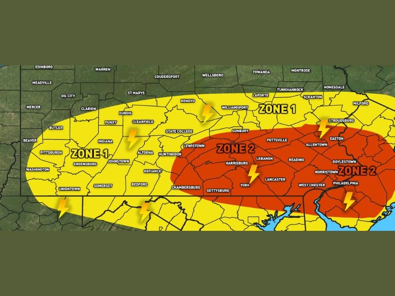
Severe Storms With 60 to 70mph Winds and Quarter Size Hail Targeting Southern and Eastern Pennsylvania Including Harrisburg Allentown and Philadelphia Through Wednesday
PENNSYLVANIA — A strong cold front is bringing a significant severe weather threat to southern and eastern Pennsylvania Wednesday afternoon and evening, with the best risk window running from 3 PM to 9 PM. Zone 2 covering Harrisburg, Allentown, Philadelphia, Reading, and Lancaster faces the highest threat with wind gusts of 60 to 70 mph and quarter size or larger hail possible with the strongest storms. Zone 1 covering Pittsburgh, State College, and Williamsport carries isolated strong to severe storm potential with wind gusts reaching 55 to 65 mph.
Zone 2 Harrisburg Allentown and Philadelphia Face 60 to 70mph Winds and Large Hail
The red Zone 2 covering southern and eastern Pennsylvania from Harrisburg eastward through Allentown, Philadelphia, Lancaster, Reading, and Norristown carries the highest severe weather confidence Wednesday afternoon. Wind gusts of 60 to 70 mph and quarter size or larger hail are possible with the strongest storm clusters that develop ahead of the cold front during the 3 PM to 9 PM window.
Sunshine ahead of the front today is building instability that will fuel damaging storm clusters as the cold front pushes through the region.
Zone 1 Covers Pittsburgh State College and Williamsport With 55 to 65mph Gusts
The yellow Zone 1 covering Pittsburgh, State College, DuBois, and Williamsport carries isolated strong to severe storm potential with wind gusts reaching 55 to 65 mph in the strongest cells. Torrential downpours and frequent lightning are additional non-severe impacts expected across both Zone 1 and Zone 2 through the evening hours.
Multiple storm clusters with damaging wind segments are possible given the combination of instability and wind shear expected ahead of the cold front passage.
All Pennsylvania Residents Should Have Alerts Active Before 3PM Wednesday
With severe weather possible across a large portion of Pennsylvania from 3 PM through 9 PM, all residents in the outlined zones should have multiple ways to receive warnings active well before the storm window opens. Move to an interior room on the lowest floor if a severe thunderstorm or tornado warning is issued for your location during the afternoon and evening hours today.
Stay with NapervilleLocal.com for the latest weather updates and local forecast coverage.

I’ve lived in Naperville long enough to see how quickly our community changes — from new developments downtown to sudden shifts in our Midwest weather. Reporting on Naperville news and daily forecasts gives me the chance to keep neighbors informed about what really matters. My goal is simple: deliver clear, timely updates so you always know what’s happening in our city and what to expect from the skies above.