
Severe Thunderstorms With 60 MPH Winds and Embedded Tornadoes Target New York to Alabama Today While Large Hail Threatens Colorado Nebraska and Wyoming
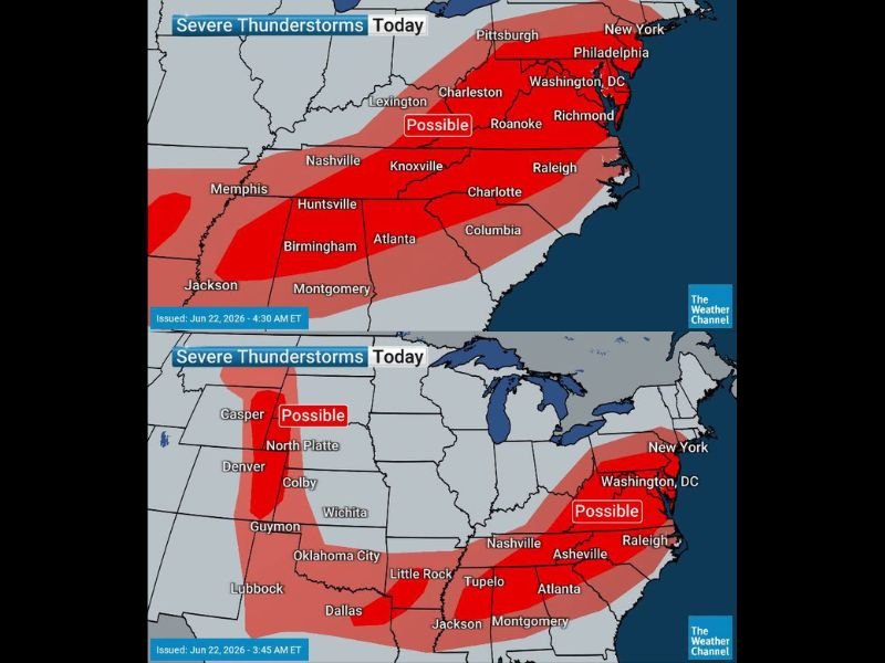
NEW YORK — A widespread severe thunderstorm outbreak is expected today across a massive corridor stretching from New York to Alabama, following a weekend that produced nearly 50 tornadoes across the country. While the tornado risk has diminished compared to the weekend, numerous thunderstorms capable of winds exceeding 60 mph and embedded tornadoes remain possible from the Northeast down through the Deep South.
Storms are expected to begin firing by early afternoon across the affected region. A separate large hail threat is simultaneously setting up across Eastern Colorado, Western Nebraska, and Eastern Wyoming.
60 MPH Winds and Embedded Tornadoes From New York to Alabama
The primary severe threat today focuses on a broad swath from New York, Philadelphia, and Washington D.C. southward through Richmond, Raleigh, Charlotte, Atlanta, Birmingham, and Montgomery. Thunderstorms producing wind gusts of 60 mph or greater are likely across this corridor, with embedded tornadoes possible in the most organized storm cells.
Storm Threat Extends Into the Tennessee Valley and Deep South
A second corridor of severe thunderstorm risk extends from Memphis and Nashville through Knoxville, Huntsville, and Jackson, with the threat connecting into the broader eastern storm zone. The entire swath from the Mid-Atlantic through the Deep South should remain alert for rapidly developing storm conditions beginning early afternoon.
Large Hail Threat Targets Eastern Colorado and Western Nebraska
Separate from the eastern severe weather setup, thunderstorms with large hail measuring two inches or greater in diameter are expected across Eastern Colorado, Western Nebraska, and Eastern Wyoming. Areas near Casper, North Platte, Colby, and Denver should be alert for damaging hailstones with any storm that develops this afternoon.
Active Pattern Expected to Continue Through the Week
Forecasters note that this week will remain active, with storm chances returning across a variety of regions each day. Residents across all affected areas are encouraged to check forecasts each morning and have a way to receive warnings as the unsettled pattern continues.
Stay with NapervilleLocal.com for the latest weather updates and local forecast coverage.

I’ve lived in Naperville long enough to see how quickly our community changes — from new developments downtown to sudden shifts in our Midwest weather. Reporting on Naperville news and daily forecasts gives me the chance to keep neighbors informed about what really matters. My goal is simple: deliver clear, timely updates so you always know what’s happening in our city and what to expect from the skies above.