
Severe Wind Gusts and Brief Tornado Possible Across Central Alabama Including Birmingham and Tuscaloosa Friday Afternoon May 22
CENTRAL ALABAMA — A late May severe weather setup is in play across central Alabama on Friday, May 22, 2026, as ingredients capable of producing a severe wind gust or brief low-intensity tornado move through the region by 2PM. This is not a guaranteed severe day but the threat is real enough that residents across the affected corridor need to remain alert through the afternoon.
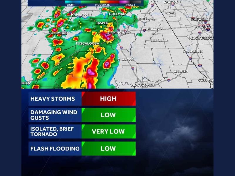
Heavy Storm Cores Tracking Through Birmingham and Tuscaloosa Corridor by 2PM Friday
Futuretrack simulation valid at 2PM Friday shows moderate to heavy storm cores pushing directly through the Birmingham and Tuscaloosa corridor, extending northward through Jasper and Cullman and westward toward Hamilton and Columbus. Dense red and yellow radar signatures indicate heavy rain rates within the most intense cells tracking through the region.
Conditions can deteriorate quickly during the afternoon hours as these cores move through. Anyone across the Birmingham and Tuscaloosa zones should have a shelter plan ready well before 2PM arrives.
Severe Wind Gust or Brief Weak Tornado Possible But Not Guaranteed Friday
The threat today involves ingredients that might produce hazards rather than a day that will definitively deliver them. A severe wind gust or small low-intensity tornado are the primary concerns, capable of occurring quickly over very small areas with little to no warning time.
The fast and localized nature of this threat makes personal weather awareness especially critical on Friday. Residents should not wait for an official warning before seeking shelter if conditions rapidly deteriorate nearby.
Late May Pattern Keeps Broader Threat Active From Gadsden Through Montgomery Friday
The threat area extends beyond the Birmingham core, with storm activity also possible across Gadsden, Anniston, Clanton, and toward Montgomery to the south. This late May setup is a recurring pattern where subtle atmospheric ingredients combine to briefly produce hazardous conditions without a classic organized severe system in place.
Staying connected to local weather alerts and monitoring rapidly changing radar trends through Friday afternoon is the most important action residents across central Alabama can take today. Preparedness and awareness remain the best tools given the uncertainty in today’s forecast. Stay with NapervilleLocal.com for the latest weather updates and local forecast coverage.

I’ve lived in Naperville long enough to see how quickly our community changes — from new developments downtown to sudden shifts in our Midwest weather. Reporting on Naperville news and daily forecasts gives me the chance to keep neighbors informed about what really matters. My goal is simple: deliver clear, timely updates so you always know what’s happening in our city and what to expect from the skies above.