
Soaking Rain and Cool Temperatures in the 50s and 60s Sweeping Across Central and Eastern North Carolina Including Raleigh, Greenville, and Wilmington This Saturday
NORTH CAROLINA — A low-pressure system tracking along the coast will push widespread rain inland across North Carolina on Saturday, with the heaviest and most persistent rainfall targeting Central and Eastern NC through mid to late afternoon. Temperatures will run noticeably cooler statewide, settling into the 50s and 60s for most areas. While the rain is welcome, it will not be enough to end the ongoing long-term drought, which has left most areas 10 to 15 inches below normal precipitation levels.
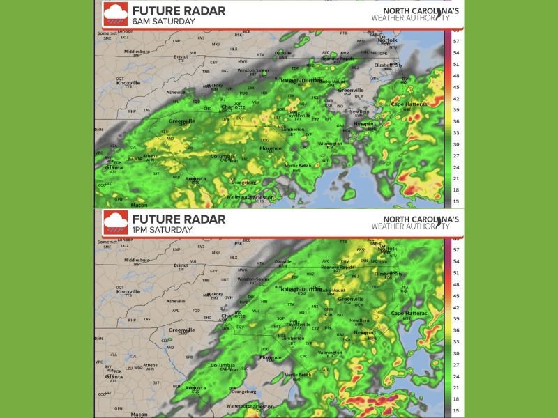
Soaking Rain Targets Central and Eastern NC Through Mid to Late Afternoon
Central and Eastern North Carolina face the highest rain totals on Saturday, with widespread light to potentially moderate showers possible through the mid to late afternoon hours. Cities including Raleigh-Durham, Rocky Mount, Greenville, New Bern, Wilmington, and Lumberton all fall within the zone seeing the most impactful and prolonged rainfall of the day.
The low-pressure system is speeding up, but enough moisture will stream inland to produce a genuine soaking rain across these eastern regions before conditions begin to clear. By late afternoon and evening, most areas will trend toward light drizzle at best before gradually improving.
Mountains and Foothills See Only Isolated Showers and Drizzle Through Midday
West of Winston-Salem across the mountains and foothills, the rain story is far less significant. Isolated showers and drizzle are expected through around midday before skies turn mostly cloudy. Not much rainfall accumulation is expected across the mountain and foothill zones, and warmer temperatures will be found further to the west where the least rain is anticipated.
Areas including Asheville, Hickory, and Charlotte will see some activity in the morning before conditions settle into a cloudy but drier afternoon. Residents in these western zones should not expect meaningful rain totals from this system.
Drought Conditions Persist Despite Saturday Rain Across Eastern Regions
While any rainfall is beneficial, Saturday’s event will not make a meaningful dent in the long-term drought affecting North Carolina. Most areas across the state remain 10 to 15 inches below normal precipitation, and a single rain event of this scale will only provide marginal relief, particularly benefiting Eastern NC the most.
Temperatures statewide will run cool throughout Saturday, holding in the 50s and 60s across the majority of the state. Residents should treat the cooler and wetter Saturday as a brief reprieve rather than a drought-ending event. Stay with NapervilleLocal.com for the latest weather updates and local forecast coverage.

I’ve lived in Naperville long enough to see how quickly our community changes — from new developments downtown to sudden shifts in our Midwest weather. Reporting on Naperville news and daily forecasts gives me the chance to keep neighbors informed about what really matters. My goal is simple: deliver clear, timely updates so you always know what’s happening in our city and what to expect from the skies above.