
SPC Issues Moderate Risk With Gorilla Hail and EF2+ Tornado Potential Across Central and Eastern Oklahoma Including Oklahoma City and Tulsa
CENTRAL AND EASTERN OKLAHOMA — The Storm Prediction Center has issued a Moderate Risk designation for central and eastern Oklahoma today, driven by an extreme gorilla hail threat and the potential for EF2 or stronger tornadoes across the region. This marks the highest hail risk issued by the SPC since the agency rolled out its new hatch area system. A 10% significant tornado hatch area has been issued for the same zone, underscoring just how dangerous today’s setup is across Oklahoma and into northern Texas.
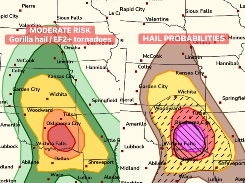
Moderate Risk Core Centered on Oklahoma City and Tulsa
The Moderate Risk zone sits squarely across central and eastern Oklahoma, with the highest threat centered around Oklahoma City, Tulsa, and Woodward. This is the SPC’s second highest risk category, reserved for setups where widespread significant severe weather is expected.
The core of the most dangerous conditions falls within this corridor, placing millions of residents under a serious severe weather threat. Residents should have shelter plans finalized well before storms arrive today.
Gorilla Hail Threat Highest Since New SPC Hatch System Introduced
The hail probability maps show an extraordinary concentration of destructive hail potential centered over the same Oklahoma corridor. The innermost magenta hatched zone represents the area most likely to receive gorilla hail — hailstones significantly larger than golf ball size capable of causing catastrophic damage to vehicles, rooftops, and structures.
SPC forecasters confirmed this is the highest hail risk designation issued since the new hatch area tool was introduced, making today’s setup historically significant from a hail threat standpoint alone.
EF2 Plus Tornado Potential Covering the Same Zone
Today’s setup carries a meaningful risk for significant tornadoes rated EF2 or stronger across the Moderate Risk corridor. A 10% significant tornado hatch area covers central and eastern Oklahoma, indicating atmospheric conditions favorable for long-track and potentially violent tornado development.
Residents across Oklahoma City, Tulsa, Woodward, and Wichita Falls should keep multiple weather alert systems active and stay shelter-ready throughout the full duration of today’s severe weather threat. Stay with NapervilleLocal.com for the latest weather updates and local forecast coverage.

I’ve lived in Naperville long enough to see how quickly our community changes — from new developments downtown to sudden shifts in our Midwest weather. Reporting on Naperville news and daily forecasts gives me the chance to keep neighbors informed about what really matters. My goal is simple: deliver clear, timely updates so you always know what’s happening in our city and what to expect from the skies above.