
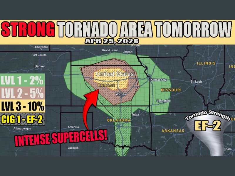
Strong Tornado Area With Intense Supercells and EF2 Tornado Potential Targeting Central Kansas Including Wichita and Salina April 25 With 10% Tornado Probability at the Core
CENTRAL KANSAS — The active severe weather pattern continues into April 25, 2026, with the threat shifting north and focusing on central Kansas, where intense supercells capable of producing strong tornadoes and very large hail are expected. The core of the most significant risk carries a Level 3 designation at 10% tornado probability, with tornado strength reaching EF-2 potential across the outlined zone covering central Kansas and surrounding areas.
Level 3 Core Targets Central Kansas With EF2 Tornado Potential
The highest risk zone sits across central Kansas, depicted with hatching on today’s outlook map, indicating the area where significant tornado development is most likely. A Level 3 designation at 10% probability represents a meaningful and serious tornado threat, with the CIG 1 indicator confirming EF-2 strength tornadoes are possible from intense supercell development across the region.
The broader Level 2 zone at 5% extends outward across a wider Kansas footprint, while the outer Level 1 area at 2% stretches further into neighboring states. Forecasters have noted the current outlook appears positioned a bit far north, meaning later updates could extend the Level 2 and Level 3 areas southward to include Wichita and Salina more prominently.
Dryline Along I-35 Adds Isolated Storm Threat Toward DFW
A dryline extending south along the I-35 corridor toward the Dallas-Fort Worth area introduces an additional storm initiation question mark for April 25. Storm development along this boundary remains unclear, but if initiation were to occur, storms would likely be more isolated and random in nature while still carrying significant intensity.
Residents across central Kansas, Wichita, and Salina should monitor forecast updates closely through the day as the outlook may be adjusted southward in later SPC updates. Shelter plans should be finalized and weather alert systems kept active throughout the full severe weather window on April 25. Stay with NapervilleLocal.com for the latest weather updates and local forecast coverage.

I’ve lived in Naperville long enough to see how quickly our community changes — from new developments downtown to sudden shifts in our Midwest weather. Reporting on Naperville news and daily forecasts gives me the chance to keep neighbors informed about what really matters. My goal is simple: deliver clear, timely updates so you always know what’s happening in our city and what to expect from the skies above.