
Stage 2 Flood Alert Active Across Houston and South Texas Including Corpus Christi, Lake Jackson, and Victoria as Heavy Rain and Storms Escalate Saturday Night Through Monday
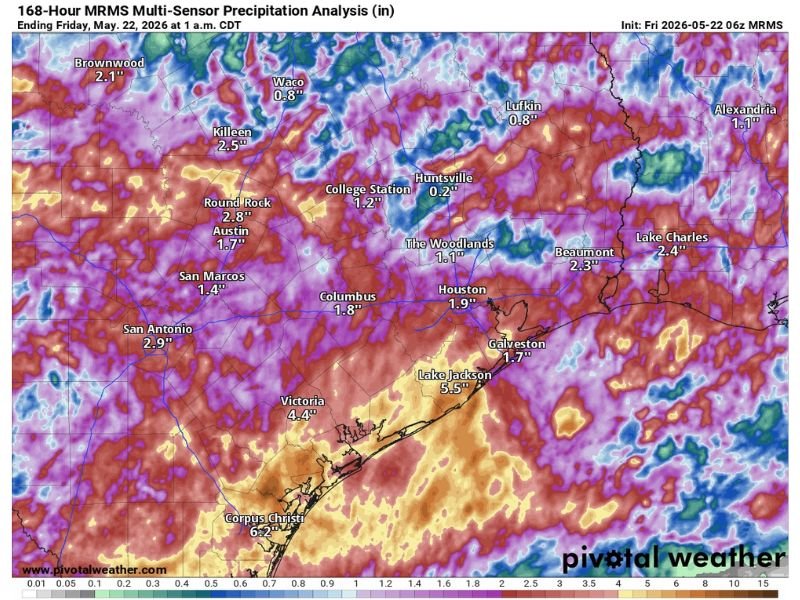
HOUSTON AND SOUTH TEXAS — A serious and escalating flood threat is building across the Houston area and broader South Texas region heading into the weekend, with a Stage 2 flood alert remaining active through at least Monday as rain and storm chances ramp up significantly from Saturday night onward. The 168-hour MRMS multi-sensor precipitation analysis ending Friday, May 22 at 1AM CDT already shows highly variable rainfall totals across the region, with southern zones bearing the heaviest accumulations. Flash flooding remains a distinct possibility as additional widespread heavy rainfall arrives on top of what has already fallen this week.
168-Hour Precipitation Analysis Shows Heavy Southern Totals Led by Corpus Christi and Lake Jackson
The week-long MRMS precipitation analysis shows the most significant rainfall concentrated across the southern Texas corridor, with Corpus Christi leading all recorded totals at 6.2 inches and Lake Jackson following closely at 5.5 inches through Friday morning. Victoria has recorded 4.4 inches while San Antonio sits at 2.9 inches and Round Rock at 2.8 inches across the analysis period.
Closer to the Houston metro, the city itself has received 1.9 inches so far this week with Beaumont at 2.3 inches, Lake Charles at 2.4 inches, and Killeen recording 2.5 inches. The variable nature of totals across the region reflects an uneven but widespread rainfall pattern that has been building all week.
Everyone in the Houston Region Expected to See Rain and Storm Chances Saturday Night Through Monday
Unlike the variable and scattered nature of this week’s rainfall, forecasters are expecting widespread participation in rain and storm activity across the entire Houston region from Saturday night through Monday. This is not a hit-or-miss event but rather a region-wide threat that will impact communities regardless of location across the broader Houston corridor.
The shift to a more widespread and organized heavy rainfall setup significantly raises the flood risk for areas already holding meaningful rainfall totals from earlier in the week. Saturated ground across the southern zones will have little capacity to absorb new rainfall as the weekend event arrives.
Stage 2 Flood Alert Remains Active Through Monday as Flash Flooding Stays a Distinct Possibility
A Stage 2 flood alert is currently active across the Houston area and will remain in place through at least Monday given the elevated and persistent flood threat through the weekend. Flash flooding is identified as a distinct possibility as heavy rain from Saturday night onward falls on already-saturated ground across the region.
Residents across Houston, Lake Jackson, Victoria, Corpus Christi, and surrounding communities should finalize flood safety preparations before Saturday night arrives. Avoiding flooded roadways, monitoring local flood warnings, and having an emergency action plan ready are critical steps for everyone across the South Texas flood risk zone heading into the weekend.
Stay with NapervilleLocal.com for the latest weather updates and local forecast coverage.

I’ve lived in Naperville long enough to see how quickly our community changes — from new developments downtown to sudden shifts in our Midwest weather. Reporting on Naperville news and daily forecasts gives me the chance to keep neighbors informed about what really matters. My goal is simple: deliver clear, timely updates so you always know what’s happening in our city and what to expect from the skies above.