
TORCON 4 Tornado Risk and 2-Inch Plus Hail Threatening ArkLaTex Including Texarkana, Shreveport, and Dallas Today With Central Mississippi at TORCON 3
ARKLАТEX AND SURROUNDING REGION — The Weather Channel TORCON index has been upgraded to 4 across the ArkLaTex region today, covering a core zone centered around Texarkana, Shreveport, Tyler, and Dallas as tornado and hail threats intensify across the south-central United States.
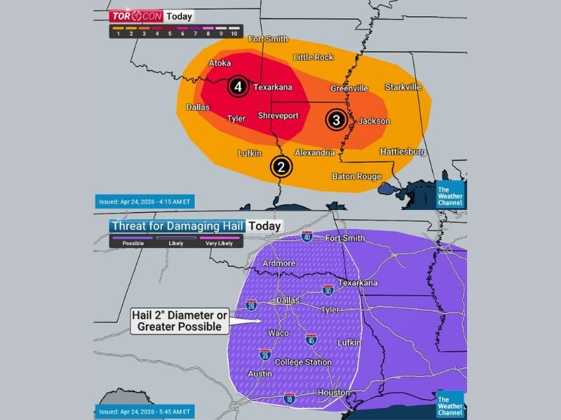
The TORCON drops to 3 across Central Mississippi including Jackson, and sits at 2 across the Alexandria and Baton Rouge corridor further south. Alongside the elevated tornado risk, a significant damaging hail threat with hailstones 2 inches in diameter or larger is expected across Oklahoma and Texas today, covering a very large geographic footprint from Dallas through Houston.
TORCON 4 Core Zone Centered on Texarkana and Shreveport
The TORCON 4 designation covers the highest tornado probability zone on today’s map, centered across the ArkLaTex corridor including Texarkana, Shreveport, Tyler, Atoka, and surrounding communities. A TORCON of 4 indicates a meaningful and significant tornado probability across the outlined zone, placing the ArkLaTex region among the highest risk areas in the country for tornado activity today.
The broader orange zone extends outward to cover Fort Smith, Little Rock, Dallas, Lufkin, and Alexandria, while a TORCON 3 zone covers the Central Mississippi corridor including Jackson, Greenville, and Starkville. The outer TORCON 2 zone reaches further south toward Baton Rouge and Hattiesburg, indicating the expansive geographic footprint of today’s tornado risk across the region.
2-Inch Plus Hail Very Likely Across Dallas Through Houston Corridor
The damaging hail threat map for today shows a very likely designation covering an enormous swath of Texas from Dallas southward through Waco, College Station, Austin, and Houston. Hailstones 2 inches in diameter or larger are explicitly highlighted as possible across this entire corridor, representing golf ball size or larger hail capable of causing significant damage to vehicles, rooftops, solar panels, and any property left outdoors.
The purple shading on the damaging hail map covers virtually the entire eastern half of Texas from the Oklahoma border southward to the Gulf Coast, indicating that the hail threat today extends well beyond just the immediate storm core areas and poses a widespread property damage risk across the region.
Tornado Risk Extends From Oklahoma Through Mississippi
The geographic scope of today’s tornado threat is extensive, stretching from southeastern Oklahoma through the ArkLaTex and into Central Mississippi. The combination of atmospheric instability, wind shear, and moisture in place across this corridor creates favorable conditions for organized and potentially significant tornado development during the afternoon and evening hours.
Residents across Texarkana, Shreveport, Tyler, Dallas, Jackson, and all communities within the TORCON 3 and 4 zones should have shelter plans finalized and multiple weather alert systems active throughout the day as tornado-producing storms develop across the region. Stay with NapervilleLocal.com for the latest weather updates and local forecast coverage.

I’ve lived in Naperville long enough to see how quickly our community changes — from new developments downtown to sudden shifts in our Midwest weather. Reporting on Naperville news and daily forecasts gives me the chance to keep neighbors informed about what really matters. My goal is simple: deliver clear, timely updates so you always know what’s happening in our city and what to expect from the skies above.