
Very Large Hail and Damaging Winds Threatening Tulsa, Oklahoma City, and Wichita Saturday April 25 as Level 3 Enhanced Risk Covers Southern Plains
SOUTHERN PLAINS — Severe storms capable of producing very large hail and damaging winds are expected Saturday afternoon April 25, 2026 across the Southern Plains, with the SPC Day 2 Outlook placing a Level 3 Enhanced Risk centered across the Tulsa and Oklahoma City corridor.
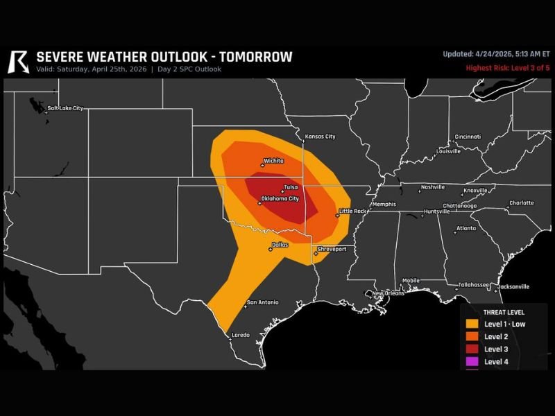
The highest risk zone sits squarely over Oklahoma and southern Kansas, with Wichita falling on the northern edge and Dallas on the southern periphery of the outlined severe weather area. Residents across the core Enhanced Risk zone should prepare now for a dangerous Saturday afternoon severe weather event.
Level 3 Enhanced Risk Centered Over Oklahoma and Southern Kansas
The Saturday Severe Weather Outlook shows a well-defined and concentrated risk structure across the Southern Plains. The darkest Level 3 Enhanced Risk core is centered directly over Oklahoma City, Tulsa, and surrounding communities, indicating the highest confidence in organized severe storm development during Saturday afternoon.
A Level 2 Slight Risk zone surrounds the Enhanced core, extending the overall risk area northward through Wichita and Kansas City and southward through Dallas and toward San Antonio. The Level 1 Low risk zone provides the outermost boundary, reaching further outward across a broader swath of the south-central United States including Memphis, Shreveport, and surrounding areas.
Very Large Hail and Damaging Winds Are Primary Threats
Two significant hazards are associated with Saturday’s severe weather setup across the Southern Plains. Very large hail represents the most impactful threat with the initial supercell phase of storm development, with hail sizes potentially reaching golf ball size or larger across the core Enhanced Risk zone centered over Oklahoma and southern Kansas.
Damaging wind gusts represent the second widespread hazard, particularly as storms potentially organize and grow upscale through the afternoon and evening hours. The combination of large hail and damaging winds makes Saturday a day where vehicle protection, outdoor plans, and travel across the Enhanced Risk corridor all need to be carefully considered before the storm window opens.
Tulsa and Oklahoma City Face the Greatest Risk Saturday
Of all communities across the Saturday risk corridor, Tulsa and Oklahoma City sit at the center of the most intense risk zone on the outlook map. These two major Oklahoma metro areas face the highest probability of encountering organized severe storms capable of producing the most significant hail and wind impacts during Saturday afternoon.
Wichita sits on the northern edge of the Enhanced zone while Dallas falls on the southern periphery, meaning both cities carry elevated but somewhat lower risk compared to the Oklahoma core. Residents across all three states within the outlined zones should finalize preparations before Saturday afternoon arrives.
Be Prepared Before Saturday Afternoon Storm Window Opens
With Saturday’s severe weather threat focused on the afternoon hours, residents across Oklahoma, southern Kansas, and northern Texas have time today to complete all preparedness steps. Secure vehicles in covered parking if possible to protect from large hail, finalize shelter plans, and ensure multiple weather alert systems are active and ready before Saturday afternoon’s storm development begins across the Southern Plains. Stay with NapervilleLocal.com for the latest weather updates and local forecast coverage.

I’ve lived in Naperville long enough to see how quickly our community changes — from new developments downtown to sudden shifts in our Midwest weather. Reporting on Naperville news and daily forecasts gives me the chance to keep neighbors informed about what really matters. My goal is simple: deliver clear, timely updates so you always know what’s happening in our city and what to expect from the skies above.