
Widespread Significant Severe Weather Targeting Missouri, Illinois, and Surrounding Areas Monday April 27 With All Modes Possible at Level 3 Enhanced Risk
MISSOURI AND ILLINOIS — Monday April 27, 2026 is shaping up as a day that needs to be watched very closely across Missouri, Illinois, and surrounding areas as the active severe weather stretch continuing through the week shifts eastward back into the region.
All modes of significant severe weather are likely, with a Level 3 Enhanced Risk carrying a 30% severe weather probability already outlined for the core risk zone centered across Missouri and Illinois. Deep moisture, strong wind shear, and significant instability will all be in place, giving Monday the ingredients needed for a rather big severe weather day across the region.
Level 3 Enhanced Risk Covers Missouri, Illinois, and Surrounding States
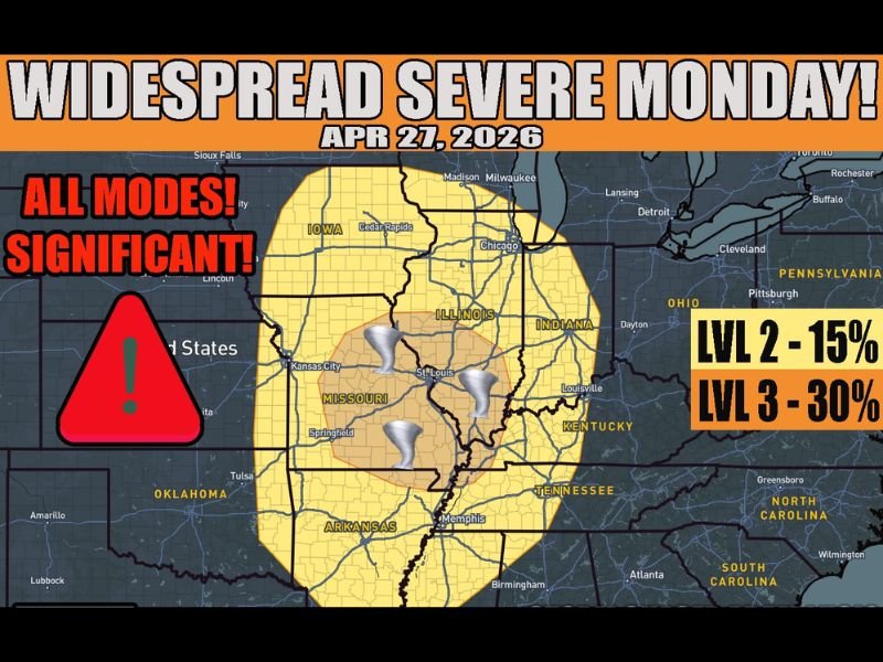
The Monday April 27 outlook map shows a Level 3 Enhanced Risk zone at 30% probability centered across Missouri and Illinois, with tornado icons visible across the St. Louis, Springfield Missouri, and southern Illinois corridor indicating the elevated tornado concern within the core risk area. A broader Level 2 Slight Risk zone at 15% extends outward to cover Iowa, Indiana, Kentucky, Arkansas, and Tennessee.
Communities across Kansas City, St. Louis, Springfield Missouri, Chicago, Cedar Rapids, Louisville, Memphis, and surrounding areas all fall within the outlined risk zones for Monday’s widespread severe weather potential.
All Modes of Significant Severe Weather Expected
Monday’s setup is being flagged as a significant all-mode severe weather event, meaning tornadoes, large hail, and damaging winds are all expected rather than just possible across the risk corridor. The combination of deep moisture, strong shear, and significant instability forecast for Monday creates an atmospheric environment capable of supporting every category of severe weather simultaneously.
The upper air pattern evolution through the weekend is expected to favor the Missouri and Illinois region specifically, with frontal positioning and storm interactions from Sunday’s activity playing a key role in determining exactly where Monday’s most intense threats materialize.
Deep Moisture, Strong Shear, and Instability All Coming Together
Three critical atmospheric ingredients are converging for Monday’s setup across Missouri and Illinois. Deep moisture pushing northward from the Gulf of Mexico will fuel storm development and intensification throughout the day. Strong wind shear in the upper levels of the atmosphere will support organized rotating storms capable of significant tornado production.
The combination of these ingredients with strong surface instability creates what forecasters describe as a potentially rather big day for severe weather across the region, pending the final positioning of frontal boundaries and any storm interactions from the Sunday severe weather events that precede Monday’s setup.
Monday Could Be the Most Significant Day of the Week
While the entire week from Thursday through Monday carries daily severe weather risks across shifting portions of the central United States, Monday’s setup across Missouri and Illinois is being highlighted as potentially the most significant single-day event of the entire stretch. Residents across both states should treat Monday as a high-priority preparedness day and ensure all severe weather plans are in place well before the storm window opens. Stay with NapervilleLocal.com for the latest weather updates and local forecast coverage.

I’ve lived in Naperville long enough to see how quickly our community changes — from new developments downtown to sudden shifts in our Midwest weather. Reporting on Naperville news and daily forecasts gives me the chance to keep neighbors informed about what really matters. My goal is simple: deliver clear, timely updates so you always know what’s happening in our city and what to expect from the skies above.