
Tornadoes, Wind, and Hail Threatening St. Louis, Paducah, and Southern Illinois Monday as SPC Upgrades Region to Level 3 Enhanced Risk With Season’s Strongest Instability Expected
ST. LOUIS, PADUCAH, AND SURROUNDING REGION — The Storm Prediction Center upgraded much of the St. Louis and Paducah region to a Level 3 Enhanced Risk for Monday April 27, 2026, as current data suggests this could be the most instability-rich severe weather setup of the entire season so far.
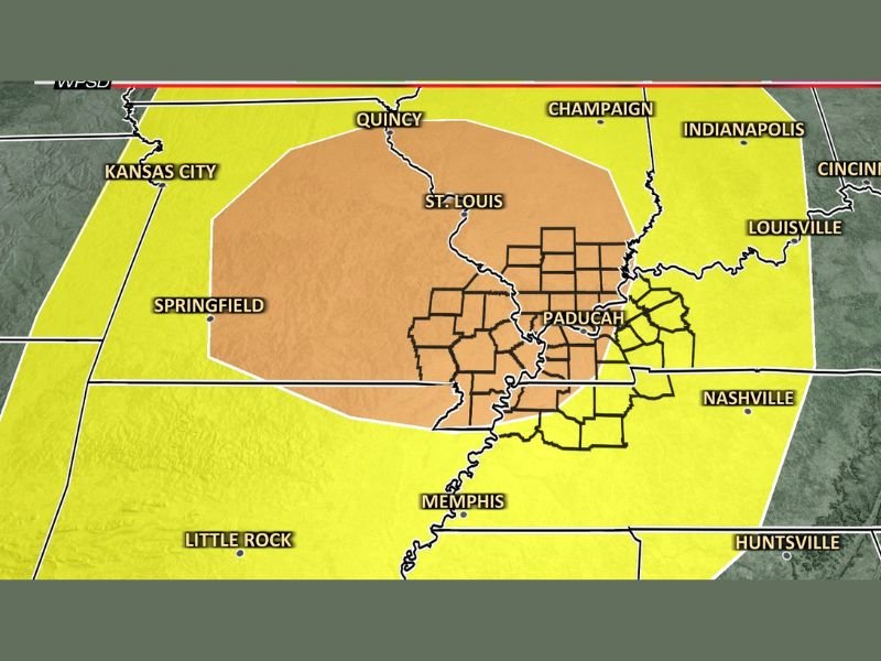
The Severe Weather Outlook shows the Enhanced Risk zone centered across southern Illinois, western Kentucky, and the Paducah corridor, with a broader Slight Risk extending outward through St. Louis, Quincy, Champaign, Indianapolis, Louisville, Nashville, and Memphis. Tornadoes, damaging winds, and large hail are all possible with Monday’s setup.
Season’s Most Instability Expected to Fuel Monday’s Storms
The most significant detail emerging from the current data is the extraordinary instability expected to be in place across the region on Monday. A surge of warm and humid air early in the day will provide more fuel for storm development than any previous severe weather event this season, giving Monday’s storms access to an unprecedented amount of atmospheric energy.
A low pressure system passing to the northwest combined with an incoming cold front will provide the trigger needed to ignite storms within this highly unstable air mass. The combination of record seasonal instability and a well-defined triggering mechanism creates the big picture ingredients for a significant severe weather event.
Enhanced Risk Centered Across Paducah and Southern Illinois
The Level 3 Enhanced Risk zone on Monday’s outlook is centered across the Paducah Kentucky and southern Illinois region, with the hatched counties within the Enhanced zone indicating the highest concentration of severe weather concern. St. Louis, Springfield, and Quincy fall within the broader Slight Risk zone, while the outer Marginal Risk extends further to cover Kansas City, Champaign, Indianapolis, Cincinnati, Louisville, and Nashville.
The exact placement of the Level 2 versus Level 3 boundaries may shift as additional data arrives over the coming days, but forecasters are confident the overall big picture setup remains consistent and concerning regardless of minor boundary adjustments.
Key Uncertainties Still to Be Resolved Before Monday
Several important questions remain unanswered as of this update that will significantly influence Monday’s ultimate severe weather outcome. How Sunday night’s storms to the west affect the environment, whether a cap develops Monday that could limit or focus storm development, the favorability of upper level winds, and whether the peak threat window falls in the afternoon or evening are all variables still being refined.
These uncertainties mean that Monday’s forecast will evolve meaningfully over the next few days and residents should monitor updated outlooks daily rather than assuming current risk zone placements are final.
Stay Informed and Prepare Now Without Panic
The goal of early awareness about Monday’s setup is preparedness rather than panic. Being informed several days in advance allows residents across St. Louis, Paducah, and surrounding communities to review shelter plans, ensure weather alert systems are functioning, and make logistical preparations calmly before the storm window arrives. Stay tuned to updated forecasts as details come into sharper focus through the weekend. Stay with NapervilleLocal.com for the latest weather updates and local forecast coverage.

I’ve lived in Naperville long enough to see how quickly our community changes — from new developments downtown to sudden shifts in our Midwest weather. Reporting on Naperville news and daily forecasts gives me the chance to keep neighbors informed about what really matters. My goal is simple: deliver clear, timely updates so you always know what’s happening in our city and what to expect from the skies above.