
Widespread Snow Blanketing Colorado, Kansas and Nebraska Wednesday Including Denver, Garden City and Kearney With 1 to 2 Feet Possible at Higher Colorado Elevations in May
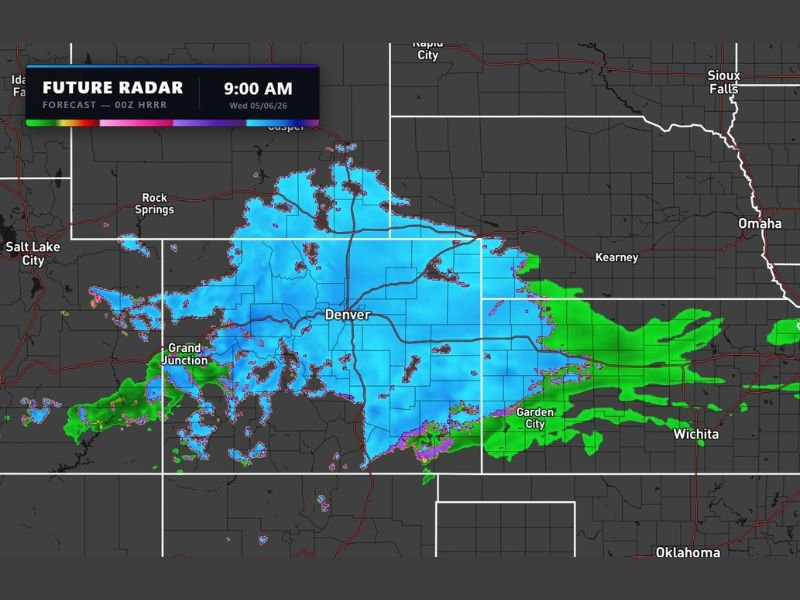
COLORADO — Widespread snow is arriving Wednesday, May 6, 2026, across Colorado, Kansas, and Nebraska in a remarkable and rare mid-May winter storm event. Future radar forecast valid at 9 AM Wednesday is showing a massive blue snow shield covering Denver and stretching eastward through Garden City, Kearney, and the Kansas and Nebraska plains. Higher elevations across Colorado are forecast to receive 1 to 2 feet of snow, making this one of the most significant late season snow events in recent memory for the region.
Massive Snow Shield Covers Denver Through Colorado Plains Wednesday Morning
Future radar at 9 AM Wednesday shows the snow shield fully established across the entire Denver metro and stretching broadly eastward across the Colorado plains toward the Kansas border. The blue coverage zone on HRRR model data is deep and expansive, confirming widespread and ongoing snowfall across a multi-state footprint during the Wednesday morning hours.
Rock Springs and the Wyoming corridor are also sitting inside the snow coverage area, with the system’s northern extent reaching well into Wyoming through the morning hours.
1 to 2 Feet of Snow Possible at Higher Colorado Elevations Wednesday
Higher elevations across Colorado are forecast to receive between 1 and 2 feet of snow through the Wednesday event, making mountain travel extremely dangerous and potentially impossible across key passes and corridors. This is a May snowfall event delivering winter storm level accumulations across the Colorado high country.
Lower elevations including the Denver metro are tracking meaningful accumulations as well, with the snow shield positioned directly over the city through the morning hours on the HRRR forecast.
Snow Extends Into Kansas and Nebraska Reaching Garden City, Kearney and Wichita
The snow and rain shield pushes well into western and central Kansas and Nebraska, with Garden City, Kearney, and Wichita all sitting inside or on the edge of the precipitation zone. Residents across western Kansas and southern Nebraska should prepare for accumulating snow and hazardous travel conditions through Wednesday morning and afternoon. Stay with NapervilleLocal.com for the latest weather updates and local forecast coverage.

I’ve lived in Naperville long enough to see how quickly our community changes — from new developments downtown to sudden shifts in our Midwest weather. Reporting on Naperville news and daily forecasts gives me the chance to keep neighbors informed about what really matters. My goal is simple: deliver clear, timely updates so you always know what’s happening in our city and what to expect from the skies above.