
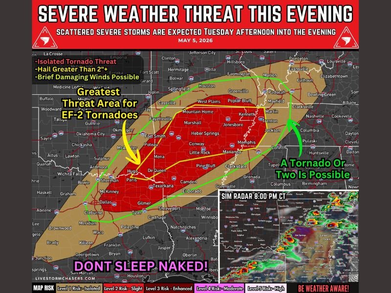
EF-2 Tornado Threat, 2 Inch Plus Hail and Damaging Winds Targeting Arkansas, Northeast Texas and Western Tennessee Including Little Rock, Fort Smith and Memphis Tuesday Afternoon Into Tonight
ARKANSAS — A dangerous and significant severe weather event is unfolding today, Tuesday May 5, 2026, across a corridor stretching from northeast Texas through Arkansas into western Tennessee. The greatest threat area for EF-2 tornadoes is centered across central and southern Arkansas, with the red high-risk zone covering Little Rock, Fort Smith, Jonesboro, Conway, Mena, De Queen, and Texarkana. Large to very large hail exceeding 2 inches and damaging winds complete the hazard profile through tonight.
EF-2 Tornado Threat Greatest Across Central and Southern Arkansas This Afternoon
The highest risk red zone identifies central and southern Arkansas as the greatest threat area for EF-2 tornado development. The environment strongly supports discrete supercells this afternoon, and any sustained storm that forms has the potential to quickly become severe and produce a strong tornado.
Wind profiles across central Arkansas into western Tennessee are described as most favorable for tornado development, making this the most dangerous portion of the entire risk corridor through the late afternoon and evening hours.
2 Inch Plus Hail and Damaging Winds Threatening Northeast Texas Through Western Tennessee
Large to very large hail with potential exceeding 2 inches is possible with stronger supercell storms developing from northeast Texas through Arkansas. Dallas, Tyler, Gilmer, Shreveport, and the surrounding northeast Texas corridor all fall inside the broader risk zone.
As storms mature and merge into clusters later tonight, the primary threat shifts toward damaging winds. The cluster wind threat will be most significant during the evening into overnight hours across the eastern portions of the risk zone including Memphis, Jackson, and western Tennessee.
Storms Develop This Afternoon Before Organizing Into Supercells Through the Evening
Storm development begins this afternoon across northeast Texas into Arkansas, with discrete supercells possible during the late afternoon and evening hours. By tonight, storms may consolidate into clusters, increasing the damaging wind threat significantly.
Residents across the entire risk zone must have multiple ways to receive warnings active right now and be ready to act immediately when warnings are issued. Stay with NapervilleLocal.com for the latest weather updates and local forecast coverage.

I’ve lived in Naperville long enough to see how quickly our community changes — from new developments downtown to sudden shifts in our Midwest weather. Reporting on Naperville news and daily forecasts gives me the chance to keep neighbors informed about what really matters. My goal is simple: deliver clear, timely updates so you always know what’s happening in our city and what to expect from the skies above.