
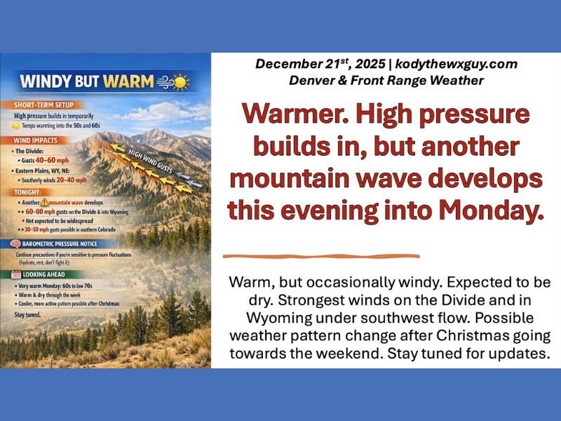
Colorado Weather Outlook Shows Warm Temperatures, Mountain Wave Winds Up to 60–80 MPH, and Possible Pattern Shift After Christmas
Colorado — A warm and unusually mild stretch of weather is taking shape across Colorado as high pressure builds in, bringing temperatures well above seasonal averages and setting the stage for mountain wave wind events capable of producing 60–80 mph gusts into Monday. While conditions remain mostly dry statewide, forecasters say a potential pattern change may arrive later in the week following Christmas.
High Pressure Triggers Warm Temperatures Across the State
Meteorologists report that this week will feature a significant warm-up, with temperatures climbing into the 50s, 60s, and even low 70s in some areas by Monday. The warming trend is driven by a strong high-pressure system shifting into the region, redirecting the jet stream and producing a southwest flow that favors warmer air surges along the Front Range.
Despite unusually warm readings for late December, forecasters emphasize that this setup does not eliminate the region’s wind potential. The change in upper-level flow distribution is causing the atmosphere to favor mountain wave formation, a phenomenon known to generate strong and occasionally damaging winds on the Continental Divide and into Wyoming.
Mountain Wave Winds Expected Sunday Night Into Monday
According to the latest forecast graphics, a mountain wave is expected to develop Sunday night into Monday, delivering:
- 40–60 mph gusts on the Divide
- 60–80 mph gusts extending into Wyoming
- 30–50 mph gusts possible in southern Colorado
While these winds are not expected to be widespread, they may affect communities at higher elevations, especially those living above 7,000 feet or along foothill regions historically prone to wind events.
Forecasters note that although this is not expected to mimic last week’s extreme, damaging wind episode, the strongest winds could still pose hazards in elevated terrain and open west-facing slopes. Residents in these areas are advised to stay alert, secure loose outdoor items, and monitor updated advisories.
Dry Conditions Continue With Slight Chance of Christmas Day Precipitation
Aside from mountain snow signals that fizzled out in earlier forecast models, Colorado is expected to remain dry through much of the week. A slight chance of precipitation remains in the forecast for Christmas Day, but confidence is currently low. Meteorologists will continue monitoring any late adjustments that might introduce moisture into the region.
Possible Pattern Change After the Holiday
Looking ahead toward next weekend, forecasters say another pattern shift is possible, though details remain uncertain. This change may bring cooler temperatures and a more active setup, depending on how approaching systems interact with the upper-level flow.
Residents sensitive to barometric pressure fluctuations are encouraged to take precautions, stay hydrated, and rest as needed, as rapid atmospheric changes may occur during these windy periods. For ongoing weather updates, regional forecasts, and daily outlooks, visit NapervilleLocal.com for continued coverage.

I’ve lived in Naperville long enough to see how quickly our community changes — from new developments downtown to sudden shifts in our Midwest weather. Reporting on Naperville news and daily forecasts gives me the chance to keep neighbors informed about what really matters. My goal is simple: deliver clear, timely updates so you always know what’s happening in our city and what to expect from the skies above.