
Arctic Airmass Shifts South Toward Texas, Oklahoma, and Arkansas as Late-January Pattern Signals Cold Surge and Wintry Precipitation Risk
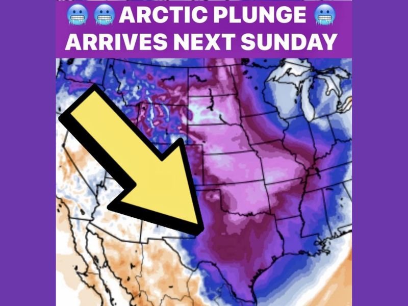
UNITED STATES — A strengthening Arctic airmass over Alaska and western Canada is now poised to shift southward into the central United States, setting the stage for a notable late-January cold surge and increasing wintry precipitation potential across parts of Texas, Oklahoma, and Arkansas as the upcoming weekend approaches.
While recent cold outbreaks have largely favored the eastern U.S., meteorologists say a warming trend across Alaska is redirecting the next upper-level trough toward the Central Plains, opening the door for a more classic winter pattern across the Southern Plains.
Pattern Shift Favors Central U.S. Cold Intrusion
Atmospheric signals show the Arctic front gaining momentum as it moves south out of Canada, driven by changes in the jet stream configuration. This shift places the Southern Plains in a climatologically favorable window for both significant cold and winter precipitation, especially during the second half of January.
Model guidance increasingly supports a southward push of colder air into Texas, Oklahoma, and Arkansas, a region that often sits on the battleground between Arctic air to the north and milder Gulf moisture to the south.
Growing Signal for a Wintry Mix Next Weekend
Forecast models are beginning to converge on the idea that a wintry mix may develop across portions of the Southern Plains as the Arctic air arrives. While specific timing, precipitation type, and accumulation details remain uncertain, confidence is growing that the setup deserves close monitoring.
This type of pattern typically supports:
- Rain transitioning to sleet or snow
- Periods of freezing temperatures following precipitation
- Rapid forecast changes as the event draws closer
Meteorologists emphasize that details will be refined throughout the week, but the overall synoptic setup strongly favors colder-than-normal conditions and at least some form of winter weather risk.
Transition Toward a More Traditional January Pattern
Beyond this single event, forecasters note that the broader signal suggests a return to a more traditional January regime, characterized by:
- Repeated Arctic intrusions
- Enhanced temperature volatility
- Increased opportunities for winter precipitation across the central U.S.
This pattern change stands in contrast to earlier January periods that favored the eastern U.S. while leaving much of the Southern Plains relatively mild.
What to Watch Going Forward
As confidence increases, forecasters will focus on:
- The exact track of the Arctic front
- The timing of moisture return from the Gulf
- Whether cold air arrives before, during, or after precipitation
Those factors will ultimately determine whether areas see cold rain, a wintry mix, or accumulating snow and ice.
For now, meteorologists agree on one thing: the signal for impactful winter weather across Texas, Oklahoma, and Arkansas is trending upward, and the coming week will be critical for fine-tuning expectations.
Stay updated with evolving winter forecasts, pattern breakdowns, and cold-weather impacts by following NapervilleLocal.com — and let us know what conditions you’re seeing where you live as winter tightens its grip across the central U.S.

I’ve lived in Naperville long enough to see how quickly our community changes — from new developments downtown to sudden shifts in our Midwest weather. Reporting on Naperville news and daily forecasts gives me the chance to keep neighbors informed about what really matters. My goal is simple: deliver clear, timely updates so you always know what’s happening in our city and what to expect from the skies above.