
Widespread Damaging Winds Likely Across Arkansas and the Mississippi Valley Including Little Rock, Memphis, and Nashville Tuesday Evening With Level 2 Risk in Place
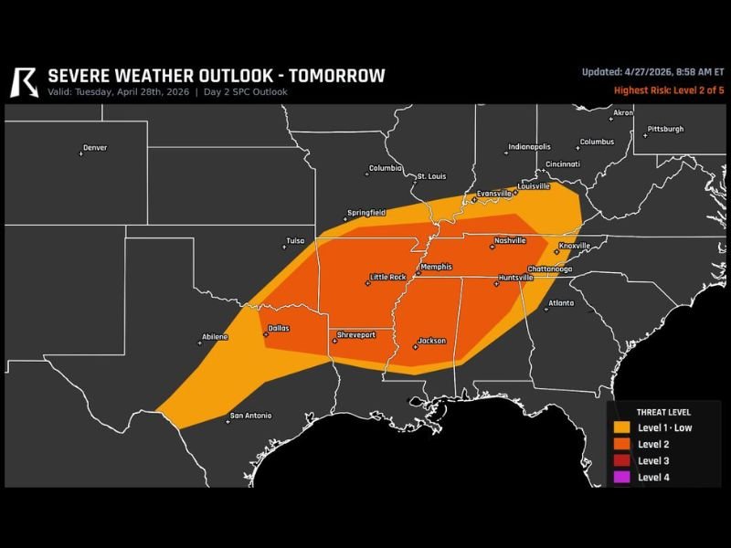
ARKANSAS AND MISSISSIPPI VALLEY — A cluster of storms capable of producing widespread damaging winds is likely to move through Arkansas and the Mississippi Valley on Tuesday evening, April 28, 2026. The Storm Prediction Center’s Day 2 outlook places a Level 2 risk across the core of the threat zone, covering a broad corridor from Little Rock and Memphis eastward through Nashville, Huntsville, and Chattanooga.
The storm system arrives as a remnant of today’s major outbreak across Missouri and Illinois, maintaining enough organization to produce significant wind damage as it pushes south and eastward through the region.
Level 2 Risk Covers Core Corridor From Arkansas Through Tennessee and Into Alabama
The highest risk on tomorrow’s outlook sits across a well-defined corridor stretching from the Arkansas and Mississippi region eastward through Tennessee and into northern Alabama. Communities including Little Rock, Memphis, Nashville, Huntsville, Chattanooga, and Knoxville all fall within the Level 2 risk zone where damaging wind gusts are the primary concern with the approaching storm cluster.
A broader Level 1 Low risk surrounds the core zone, extending the wind threat across a much wider footprint from Dallas and Shreveport in the southwest through Jackson, Mississippi and northward into the St. Louis and Evansville area. Even communities on the outer fringes of this system should remain alert as storm clusters can produce damaging gusts well ahead of their most intense cores.
Storm Cluster Moves Through Tuesday Evening Bringing Widespread Wind Damage Threat
The primary storm mode for Tuesday’s event is a cluster or squall line configuration, which strongly favors widespread damaging straight-line winds over tornado or hail production. This type of storm structure can deliver destructive wind gusts across a very large geographic area simultaneously, causing widespread tree damage, power outages, and property impacts along its entire track.
The evening arrival timing of the storm system means many residents will be at home when the most significant conditions move through. Having a weather radio or alert-enabled device active through Tuesday evening is strongly recommended for anyone across the affected region from Arkansas through Tennessee and Alabama.
Threat Extends From Texas Through the Tennessee Valley Ahead of Wednesday’s Clearing
The overall severe weather footprint for Tuesday extends from the Texas coast and San Antonio area northeastward through the entire Mississippi Valley corridor and into the Tennessee Valley. This broad swath reflects the extensive reach of the departing storm system as it sweeps through the Mid-South on Tuesday evening before gradually clearing Wednesday.
Residents across the full risk zone should prepare for a period of strong and gusty winds Tuesday evening regardless of their specific risk level designation. Securing outdoor furniture, avoiding unnecessary travel during the peak evening hours, and staying connected to local alerts will be critical steps for anyone in the path of tomorrow’s storm cluster. Stay with NapervilleLocal.com for the latest weather updates and local forecast coverage.

I’ve lived in Naperville long enough to see how quickly our community changes — from new developments downtown to sudden shifts in our Midwest weather. Reporting on Naperville news and daily forecasts gives me the chance to keep neighbors informed about what really matters. My goal is simple: deliver clear, timely updates so you always know what’s happening in our city and what to expect from the skies above.