
Major Cooldown Bringing Temperatures 10 to 20 Degrees Below Normal Across the Southern Plains and South Shutting Down Severe Weather Risk Through the First Week of May
SOUTHERN PLAINS AND SOUTH — A significant weather pattern change is on the way for the Southern Plains and South as a strong cold front delivers well-below-normal temperatures to the region through the final days of April and into the first week of May.
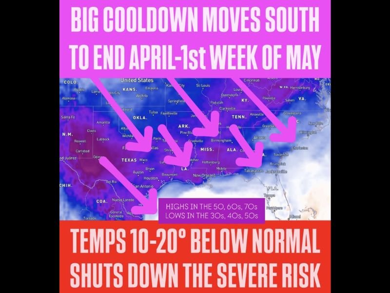
Highs will run 10 to 20 degrees below normal with lows falling 5 to 15 degrees below normal across a broad area covering Texas, Oklahoma, Arkansas, Mississippi, Alabama, Tennessee, and surrounding states. This dramatic cooldown will effectively shut down the organized severe weather risk that has dominated the region over the past several days.
Strong Cold Front Drops Highs Into the 50s, 60s, and 70s Across the Region
The incoming cold front will push temperatures well below seasonal norms across the entire Southern Plains and South, with highs only reaching the 50s, 60s, and 70s depending on location through the end of April and into early May. Overnight lows will drop into the 30s, 40s, and 50s across the affected region, bringing a sharp and noticeable contrast to the warm and volatile conditions that fueled this week’s severe weather outbreak.
Communities from Texas and Oklahoma through Arkansas, Mississippi, Alabama, and Tennessee will all feel the effects of this cold airmass as it sweeps southward through the region. The cooldown arrives after one of the more active and dangerous severe weather stretches the region has seen in recent memory.
Below Normal Temperatures Eliminate Severe Weather Threat for Early May
The primary significance of this cold front beyond the temperature drop is its ability to completely suppress the organized severe weather risk that typically peaks across the Southern Plains and South during early May. With temperatures running 10 to 20 degrees below normal, the atmospheric instability and moisture needed to fuel significant severe weather development will simply not be available across the region.
While isolated rain and storm chances remain possible for some areas during the transition period, the threat for organized severe weather outbreaks is expected to be shut down entirely through the first week of May. This represents a significant and welcome break from the active severe weather pattern that has impacted millions across the region this week.
Pattern Shift Brings Much Needed Relief After Dangerous Week of Severe Weather
After getting through the next couple of days of ongoing severe weather impacts, the entire Southern Plains and South region will transition into a quieter and cooler weather pattern heading into May. The break from severe weather will allow communities that sustained damage this week the opportunity to begin recovery and damage assessment efforts under more favorable conditions.
The cooldown is expected to persist through the first week of May before the pattern gradually moderates. Residents across the affected region can look forward to a period of calm and significantly cooler weather following one of the most active severe weather weeks of the season so far. Stay with NapervilleLocal.com for the latest weather updates and local forecast coverage.

I’ve lived in Naperville long enough to see how quickly our community changes — from new developments downtown to sudden shifts in our Midwest weather. Reporting on Naperville news and daily forecasts gives me the chance to keep neighbors informed about what really matters. My goal is simple: deliver clear, timely updates so you always know what’s happening in our city and what to expect from the skies above.