
Michigan Faces Dangerous Monday Snow Squalls as Powerful Clipper Brings Blizzard-Like Travel Conditions Statewide
MICHIGAN — A fast-moving winter clipper is set to create scattered to widespread travel disruptions across Michigan on Monday, January 19, 2026, as snow, strong winds, and rapidly deteriorating road conditions combine to produce dangerous winter travel across much of the state, particularly away from Lake Michigan and Lake Superior shorelines.
Forecasters stress that while snowfall totals may vary, the combination of wind-driven snow, falling visibility, and drifting will make this a high-impact winter weather day, especially during commute hours.
Clipper System Drives Snow and Gusty Winds Across the State
An energetic Alberta clipper system is sweeping through the Great Lakes region overnight into Monday, spreading accumulating snow across interior Michigan.
Most areas away from the immediate lakeshores are expected to receive 1 to 3 inches of snow, but locally higher totals of 5 to 8 inches are possible in snowbelt regions of western and northern Lower Michigan.
What elevates this system is the wind. Gusts approaching 40 mph will lead to blowing and drifting snow, rapidly reducing visibility and making road conditions change quickly.
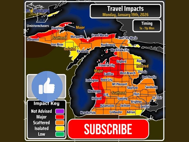
Major Travel Impacts Expected in Western and Northern Michigan
Travel impacts will range from isolated to major, depending on location and timing. The most severe conditions are expected across western Lower Michigan, including areas near Traverse City, Cadillac, Ludington, Reed City, Muskegon, Holland, and Kalamazoo.
Parts of northern Lower Michigan and the Upper Peninsula, including Houghton, Marquette, and Grand Marais, will also see dangerous travel, particularly where snow bands align with strong winds. Even areas marked as “scattered impacts” may experience sudden snow squalls, which can cause near-whiteout conditions in minutes.
Timing: Commutes Will See the Worst Conditions
The highest-impact window runs from early Monday morning through late evening, roughly 1 a.m. to 11 p.m., with both morning and evening commutes at risk.
Forecasters warn that short breaks in snowfall may be misleading, as additional squalls could redevelop quickly, increasing the risk of multi-vehicle accidents on major roadways.
Cold Exposure and Safety Risks Increase
With temperatures remaining well below freezing and persistent winds, frostbite and hypothermia risks increase sharply for anyone stranded outdoors. Drivers are advised to carry winter emergency supplies, keep fuel tanks well above empty, and prepare for longer-than-normal travel times.
Estimated Travel Delay Ranges
Expected travel delays based on impact zones include
Isolated impacts: 20–40 minutes
Scattered impacts: 40–80 minutes
Major impacts: 60–120 minutes or longer
Delays may increase quickly if crashes block primary routes or if visibility suddenly drops.
Bottom Line: A High-Risk Winter Travel Day for Michigan
This is not a routine snow event. Even where snowfall amounts remain modest, wind-driven snow and sharply reduced visibility will make Monday a dangerous day to travel across much of Michigan.
Residents are urged to limit unnecessary travel, stay weather-aware, and plan ahead for rapidly changing winter conditions. For continued updates, safety guidance, and regional winter weather coverage, follow the latest reports and join the conversation at NapervilleLocal.com.

I’ve lived in Naperville long enough to see how quickly our community changes — from new developments downtown to sudden shifts in our Midwest weather. Reporting on Naperville news and daily forecasts gives me the chance to keep neighbors informed about what really matters. My goal is simple: deliver clear, timely updates so you always know what’s happening in our city and what to expect from the skies above.