
Historic Nor’easter Slams I-95 Corridor From Delaware to Maine With 1–2 Feet of Snow and 60 MPH Blizzard Winds
UNITED STATES — A blockbuster winter storm is getting underway along the Mid-Atlantic into the Northeast, with a powerful Nor’easter expected to hammer areas from Delaware to Maine through Monday. Blizzard Warnings are in effect along much of the heavily traveled I-95 corridor, including major metro areas such as Philadelphia, New York City, and Boston, as forecasters call for widespread heavy snow and damaging winds.
This storm is being described as one of the most significant in nearly a decade for some locations, with impacts that could linger well into the week.
1–2 Feet of Snow Forecast for Major Metro Areas
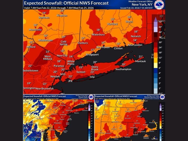
Official snowfall projections show a broad swath of 12 to 24 inches across large portions of New Jersey, the New York City metro, Long Island, Connecticut, Rhode Island, and eastern Massachusetts. The most intense banding is expected near and just inland from the coast.
Forecast maps indicate:
- Around 18–23 inches across parts of New York City, Long Island, and southern Connecticut
- Widespread 16–20 inches in areas surrounding NYC and into coastal New England
- Solid 12–18 inch totals farther inland across parts of the region
Localized amounts near or above two feet are possible where heavy snow bands persist the longest.
Blizzard Conditions With 45–60 MPH Wind Gusts
This is not just a heavy snow event. Wind gusts of 45 to 60 mph are expected in the hardest-hit areas, especially closer to the coast. Those winds, combined with heavy snowfall rates, could produce true blizzard conditions — meaning visibility may drop below a quarter mile for extended periods.
Whiteout conditions, significant drifting, and dangerous roadways are expected across much of the warning area.
Travel Will Become Dangerous, Possibly Impossible
Forecasters warn that travel will become very hazardous, if not impossible, in some areas Sunday night into Monday. Major highways, secondary roads, and city streets could become snow-covered quickly as heavy snowfall rates overwhelm plows during peak intensity.
Air travel across the Northeast corridor is also expected to face significant disruption, particularly in the Philadelphia, New York City, and Boston metro areas. Recovery from airline cancellations and delays could take several days.
A Storm That Could Be Remembered for Years
With the combination of heavy snowfall, strong winds, and widespread blizzard warnings, this Nor’easter has the potential to become a benchmark storm for parts of the Northeast. Communities from the Mid-Atlantic through New England should prepare for prolonged impacts and monitor official updates as conditions deteriorate.
For continued updates on major national weather events and how they evolve, stay with NapervilleLocal.com for the latest coverage and forecast analysis.

I’ve lived in Naperville long enough to see how quickly our community changes — from new developments downtown to sudden shifts in our Midwest weather. Reporting on Naperville news and daily forecasts gives me the chance to keep neighbors informed about what really matters. My goal is simple: deliver clear, timely updates so you always know what’s happening in our city and what to expect from the skies above.