
Historic Nor’easter Unleashes Largest Northeast Blizzard in a Decade as Massive Comma-Head Storm Swirls Off the Coast
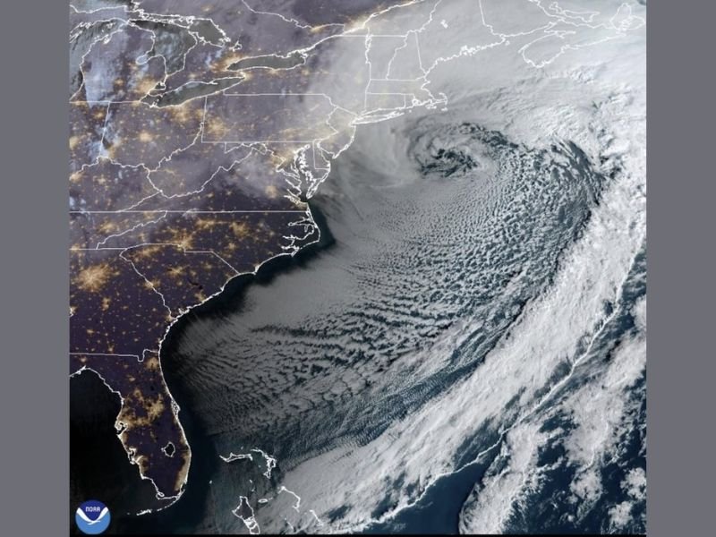
UNITED STATES — The sun rose over the Northeast this morning revealing what meteorologists are calling the biggest blizzard to impact the region in about a decade. Satellite imagery shows a massive, tightly wound Nor’easter spinning just offshore, with a dramatic “comma-head” structure stretching from the Mid-Atlantic into New England.
The storm’s swirling cloud shield dominates the western Atlantic, curling counterclockwise like a textbook winter cyclone. From space, the system appears enormous — its dense core positioned east of the New Jersey and Long Island coastline, with broad bands of snow wrapping inland across multiple states.
A Textbook Comma-Head Blizzard
The satellite image highlights the storm’s well-defined center and sweeping cloud bands, forming the classic comma shape associated with powerful winter storms. The thickest cloud mass arcs across coastal areas of:
- New Jersey
- New York
- Connecticut
- Rhode Island
- Massachusetts
This comma-head region is often where the most intense snowfall and strongest winds occur. The tightly packed cloud bands suggest strong lift and deep moisture, fueling heavy snowfall totals across parts of the Northeast.
One of the Most Significant Storms in Years
Meteorologists note that storms of this scale do not happen frequently. The structure visible offshore indicates a highly organized low-pressure system that rapidly intensified as it tracked along the East Coast.
Such powerful Nor’easters are capable of producing:
- Blizzard conditions
- Heavy snowfall accumulations
- Strong coastal winds
- Widespread travel disruptions
With the storm positioned just offshore, the Northeast bore the brunt of its western flank — the side typically associated with the heaviest snow.
Coastal and Inland Impacts
The storm’s placement allowed snow bands to sweep inland while the core circulation churned over open water. Coastal communities likely experienced the strongest wind gusts, while interior cities dealt with persistent snowfall through the night.
The size and symmetry of the storm underscore its intensity. Even as skies begin to clear in some areas, the satellite view confirms the magnitude of the system that just moved through.
A Blizzard for the History Books
Events like this are remembered not just for snowfall totals, but for their scale and visual impact. The sprawling cloud shield and tightly wrapped center reflect a winter system that will likely be referenced for years when discussing major Northeast blizzards.
As cleanup efforts begin and travel gradually resumes, the region will continue assessing the full impact of what may be the most significant winter storm in roughly ten years.
For continued coverage of major national weather events and in-depth storm analysis, stay connected with NapervilleLocal.com.

I’ve lived in Naperville long enough to see how quickly our community changes — from new developments downtown to sudden shifts in our Midwest weather. Reporting on Naperville news and daily forecasts gives me the chance to keep neighbors informed about what really matters. My goal is simple: deliver clear, timely updates so you always know what’s happening in our city and what to expect from the skies above.