
Denver and Colorado’s Front Range Turn Warm With 70s Ahead of Powerful 60–80 MPH Mountain Winds, Fire Danger, and Midweek Snow Surge
COLORADO — A dramatic weather swing is unfolding across Denver and the Front Range, where springlike warmth is quickly giving way to powerful winds, elevated fire danger, and a midweek burst of mountain snow.
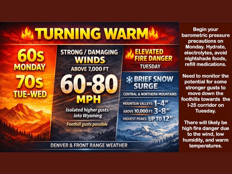
Monday starts calm and warmer, with widespread 60s east of the Continental Divide and near 50 degrees along the western slope. Winds remain manageable early, generally between 15–25 mph, especially across parts of Wyoming and the far eastern plains. But that calm doesn’t last.
Turning Warmer — For Now
Temperatures are forecast to climb even higher Tuesday, with 60s again widespread and 70s likely, especially south of I-70 along Highway 50. Strong downslope westerly winds will compress and heat the air, potentially pushing some locations into the mid to upper 70s. It’s a brief taste of early spring before the atmosphere shifts gears.
The Wind Machine Wakes Up
As zonal west-to-east flow strengthens ahead of a cold front due Wednesday, mountain wave development is expected to ramp up by Tuesday.
Forecasters are warning of strong to damaging winds above 7,000 feet, where gusts could reach 60–80 mph. Isolated higher gusts may extend into parts of Wyoming.
There is also concern that some of those stronger gusts could spill down into the foothills and potentially affect portions of the I-25 corridor, though that piece of the forecast still needs refinement. Residents in foothill communities are advised to secure loose outdoor items and prepare for gusty conditions Tuesday.
Elevated Fire Danger Tuesday
The combination of warm temperatures, low humidity, and strong winds will likely create elevated to high fire danger, particularly across the Front Range and adjacent plains.
With vegetation still dry in many areas, even small sparks could spread quickly under these conditions.
Cold Front Brings Snow to the Mountains
By Wednesday, the cold front begins pushing through Wyoming and Nebraska first before sliding into Colorado. East of the Divide, temperatures will start similarly mild but trend cooler as the front advances.
The central and northern mountains are expected to see a brief snow surge, with projected accumulations including:
- Mountain valleys: 1–4 inches
- Above 10,000 feet: 3–8 inches
- Highest peaks: up to 12 inches
Some light rain showers may develop along the Front Range, I-25 corridor, and eastern plains as the front pushes southeast Wednesday into Wednesday night.
A Classic Colorado Weather Whiplash
This pattern showcases classic Colorado weather variability — from near-70-degree warmth and fire concerns to damaging mountain winds and accumulating snow within 48 hours.
For residents along the Front Range, Tuesday will be the day to monitor closely for wind impacts, while mountain communities prepare for fresh snowfall. For continued updates on major national and regional weather events, stay connected with NapervilleLocal.com.

I’ve lived in Naperville long enough to see how quickly our community changes — from new developments downtown to sudden shifts in our Midwest weather. Reporting on Naperville news and daily forecasts gives me the chance to keep neighbors informed about what really matters. My goal is simple: deliver clear, timely updates so you always know what’s happening in our city and what to expect from the skies above.