
Michigan Daily Conditions for February 28, 2026 Show Snow Across Upper Peninsula and Dropping Temperatures Statewide
Michigan — The final day of meteorological winter is bringing snow, falling temperatures, and a wintry mix across parts of the Lower Peninsula on Saturday, February 28, 2026. Much of the central and northern portions of the state are expected to see accumulating snowfall, while areas along and south of I-94 may experience a mix of snow and freezing drizzle before potential rain farther south.
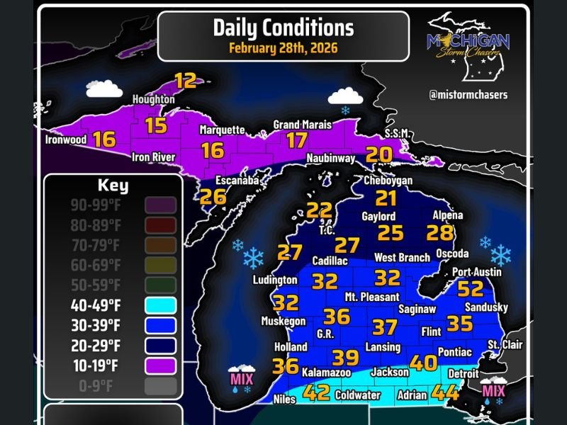
According to the Michigan Storm Chasers daily conditions graphic , most of the precipitation is forecast to remain north of I-94, with temperatures dropping through much of the day.
Heavy Snow Banding Across the Upper Peninsula
The Upper Peninsula is firmly in winter mode to close out February. Forecast high temperatures across the region remain well below freezing, supporting steady snowfall in many communities.
Reported highs include:
- Houghton: 12°
- Ironwood: 16°
- Iron River: 15°
- Marquette: 16°
- Grand Marais: 17°
- Naubinway: 20°
- Escanaba: 26°
These temperatures, mostly in the teens and 20s, indicate that snow accumulation is likely across much of the U.P. as central banding from the system tracks through the region. Windy conditions are expected early, though winds should ease as the morning progresses.
Northern Lower Peninsula Stays Below Freezing
Across the northern Lower Peninsula, temperatures remain cold enough to support snow as well.
Forecast highs include:
- Cheboygan: 21°
- Gaylord: 25°
- Alpena: 28°
- Traverse City (T.C.): 22°
- Cadillac: 32°
- Ludington: 27°
- West Branch: 32°
- Mt. Pleasant: 32°
Much of this region will see temperatures in the 20s to low 30s, keeping precipitation primarily in the form of snow. Snow icons on the map reinforce that wintry conditions are likely through much of the day.
Central and Southern Lower Peninsula See Mixed Conditions
Further south, temperatures gradually increase but remain variable across the region. The system may bring a mix of snow and freezing drizzle along and south of I-94, with the potential for plain rain in the far southern border areas if dry air is overcome.
Key forecast highs include:
- Muskegon: 32°
- Grand Rapids (G.R.): 36°
- Holland: 36°
- Lansing: 37°
- Saginaw: 37°
- Flint: 35°
- Pontiac: 40°
- Detroit: 40°
Temperatures hover close to the freezing mark across much of central Michigan, creating potential for slick spots if freezing drizzle develops.
In the far southern Lower Peninsula, warmer readings appear:
- Kalamazoo: 39°
- Jackson: 40°
- Coldwater: 42°
- Adrian: 44°
- Niles: 42°
A “MIX” indicator appears near southwestern and southeastern corners of the state , signaling the possibility of rain and snow blending in these regions.
Temperatures Expected to Drop Through the Day
Unlike a typical winter day where temperatures gradually rise, this system may cause temperatures to fall through much of Saturday, especially in areas north of I-94. That trend could lead to changing precipitation types as colder air filters southward.
Windy conditions are expected early in the day before calming as the morning progresses. The combination of wind, snow banding, and falling temperatures underscores a classic late-winter setup for Michigan.
As meteorological winter officially ends, Michigan closes the season much like it began — with widespread snow across the north and mixed precipitation across the south.
Residents should monitor local advisories for snowfall totals and road conditions, particularly in the Upper Peninsula and northern Lower Peninsula where accumulation is most likely.
For more statewide weather updates and detailed daily forecasts, visit NapervilleLocal.com for continued coverage.

I’ve lived in Naperville long enough to see how quickly our community changes — from new developments downtown to sudden shifts in our Midwest weather. Reporting on Naperville news and daily forecasts gives me the chance to keep neighbors informed about what really matters. My goal is simple: deliver clear, timely updates so you always know what’s happening in our city and what to expect from the skies above.