
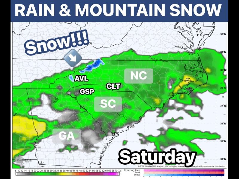
Soaking Rain With Over an Inch Possible and Rare May Mountain Snow Targeting the Carolinas and Georgia Including Asheville, Charlotte, and Greenville This Saturday
CAROLINAS AND GEORGIA — A wild and unseasonable weather setup is taking shape for Saturday, May 2, 2026, across the Carolinas and Georgia, combining a soaking rain event with the rare possibility of wet snow mixing in at higher mountain elevations. A widespread rain event will push through the region, especially south of Interstate 40, where many spots could pick up an inch or more of rainfall through the first half of the day. Mountain elevations starting in the 30s and Upstate highs struggling to reach the 50s create the recipe for wet snow to mix in at higher elevations, making this a truly remarkable early May weather setup.
Soaking Rain of an Inch or More Expected South of I-40 Through Saturday Morning
The primary rainfall event on Saturday will deliver a soaking and widespread rain across the Carolinas and Georgia, with the heaviest totals focused south of Interstate 40 through the first half of the day. Precipitation coverage on the forecast map shows a broad and well-organized green shield of rainfall extending across North Carolina, South Carolina, and northern Georgia, with the heaviest cores visible along the coastal plain and into the Upstate corridor.
Rainfall totals of an inch or more are possible across many communities south of I-40, delivering beneficial moisture to areas that have been dealing with dry conditions in recent weeks. The widespread nature of Saturday’s rainfall makes it one of the more impactful precipitation events of the past month for the region.
Rare May Mountain Snow Possible at Higher Elevations Around Asheville Early Saturday
The most remarkable aspect of Saturday’s weather setup is the potential for wet snow to mix in at higher mountain elevations across western North Carolina, particularly around and above the Asheville area where forecast precipitation type maps show blue snow shading. Mountain starting temperatures in the 30s create just enough cold air to support wet snow mixing in during the early morning hours before temperatures gradually rise through the day.
While forecasters describe this snow potential as more of a novelty than a significant weather problem, seeing any snow in early May is an extraordinary occurrence across the Southern Appalachians. Residents in the higher elevations near Asheville and surrounding mountain communities should not be surprised if they wake up to a brief period of wet snow or snow-rain mix early Saturday morning.
Upstate Highs Struggling Into the 50s Making This a Remarkably Cold Early May Day
Beyond the snow novelty, Saturday’s temperatures will be strikingly cold for early May across the Carolinas, with Upstate South Carolina highs barely reaching the 50s through the afternoon. This cold temperature profile is what makes the mountain snow possible and gives the entire Saturday weather setup its unusual and historic character for this time of year.
Communities across the Greenville, Spartanburg, and Charlotte corridors should prepare for a raw, cold, and wet Saturday that will feel significantly more like late winter than early spring. Residents with outdoor plans should dress in layers and expect persistently cool and damp conditions through much of the day. Stay with NapervilleLocal.com for the latest weather updates and local forecast coverage.

I’ve lived in Naperville long enough to see how quickly our community changes — from new developments downtown to sudden shifts in our Midwest weather. Reporting on Naperville news and daily forecasts gives me the chance to keep neighbors informed about what really matters. My goal is simple: deliver clear, timely updates so you always know what’s happening in our city and what to expect from the skies above.