
Scattered Frost and Lows Dropping Into the 30s and 40s Across North Georgia Including Atlanta and the Mountain Communities This Sunday Morning May 3
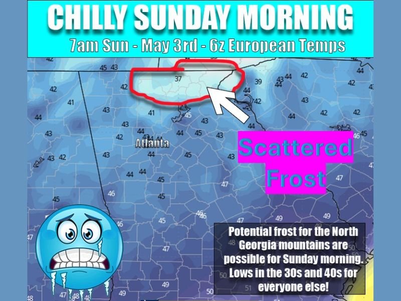
NORTH GEORGIA — A rare and unseasonable early May cold snap known as Blackberry Winter is bringing a frosty and chilly start to North Georgia this Sunday morning, May 3, 2026, with scattered frost possible across the region and temperatures dropping into the low 30s across the North Georgia mountains.
European model temperature data valid at 7 AM Sunday shows readings of 37 degrees circled across the North Georgia mountain corridor, while Atlanta and surrounding communities are forecast to see lows in the low to mid 40s. This does not appear to be heading toward a widespread hard freeze, but sensitive plants across the region will need attention and precautions before Sunday morning arrives.
North Georgia Mountains Dropping to 37 Degrees With Scattered Frost Possible Sunday
The coldest readings Sunday morning will be confined to the North Georgia mountain corridor, where temperatures are forecast to drop to 37 degrees as of the 7 AM European model guidance. Scattered frost is explicitly possible across the mountain communities Sunday morning, making this a notable and historically unusual frost event for the first weekend of May across northern Georgia.
The frost risk in the mountains is real enough that residents with sensitive vegetation, gardens, or outdoor plants at higher elevations should take protective measures before Saturday night. Covering sensitive plants or bringing them indoors before temperatures begin falling Saturday night into Sunday morning is the recommended precaution for anyone in the North Georgia mountain zone.
Atlanta and Surrounding Areas See Lows in the Low to Mid 40s Sunday Morning
While the mountain communities face the coldest conditions, Atlanta and the broader surrounding region will also experience a noticeably cold Sunday morning with lows dropping into the low to mid 40s across the metro area and surrounding counties. Temperatures in the 40s in early May represent a significant departure from seasonal norms and will make for a jacket-required morning across the region.
The 40-degree range lows across Atlanta and surrounding areas are not cold enough to produce frost at lower elevations but will still feel remarkably cold for the first weekend of May. Residents heading out early Sunday morning should dress in layers as the sharp cold airmass produces one of the coldest May mornings North Georgia has experienced in recent years.
Blackberry Winter Pattern Brings Unseasonable Cold Without a Hard Freeze Risk
The Blackberry Winter phenomenon, a well-known regional term for a brief and sharp cold snap that occurs in early May across the South, is the atmospheric pattern driving Sunday’s unusually cold conditions across North Georgia. While the cold is notable and impactful for sensitive vegetation, forecasters are not expecting conditions to deteriorate to a hard freeze level across the region.
Sensitive plants including flowers, garden vegetables, and newly planted annuals should still be protected or moved indoors as a precaution given the scattered frost potential across the mountain zones and the 40-degree readings expected across lower elevations. The cold pattern is expected to be brief with temperatures returning to more seasonal levels early next week. Stay with NapervilleLocal.com for the latest weather updates and local forecast coverage.

I’ve lived in Naperville long enough to see how quickly our community changes — from new developments downtown to sudden shifts in our Midwest weather. Reporting on Naperville news and daily forecasts gives me the chance to keep neighbors informed about what really matters. My goal is simple: deliver clear, timely updates so you always know what’s happening in our city and what to expect from the skies above.