
Rain, Mountain Snow Up to 12 Inches Above 8000 Feet, and Thunderstorms Targeting Colorado Including Colorado Springs, Pueblo, and the Palmer Divide From Thursday Noon Through Friday
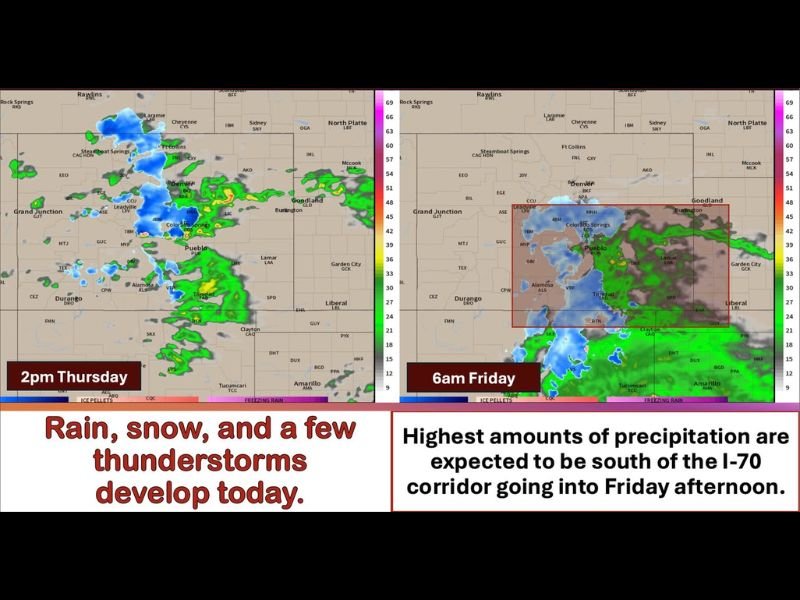
COLORADO AND FRONT RANGE — A significant storm system is spreading rain, snow, and thunderstorms across Colorado and the Front Range beginning Thursday afternoon, April 30, 2026, with precipitation lingering into Friday as upslope winds combine with a cold front and a storm system passing to the south.
The main event kicks off around noon Thursday with the heaviest precipitation focused south of Interstate 76 and north of Highway 50, particularly along and east of the Continental Divide through the I-25 corridor and into the adjacent plains. Highest precipitation amounts are expected south of the I-70 corridor going into Friday afternoon.
Snow Accumulations of Trace to 3 Inches on the Palmer Divide and Foothills
The Palmer Divide at 7,000 feet and above is forecast to see snow accumulations ranging from a trace to 3 inches, with the possibility of higher amounts for overachieving locations. Northern El Paso County and Teller County are in the same trace to 3 inch range, while foothills west of I-25 generally above 6,000 feet could see trace to 3 inches with locations above 7,000 feet expected to pick up 3 to 7 inches of snowfall through the event.
Areas above 8,000 feet are where the most significant snow accumulations are possible, with up to 12 inches forecast for the highest terrain along and east of the Continental Divide. Mountain passes including Wolf Creek Pass and La Veta Pass could see significant snow accumulations, and travelers planning to cross mountain passes should check road conditions before departing.
Rain and Thunderstorms Develop at Lower Elevations Through Thursday Afternoon and Evening
Lower elevations below 5,000 feet will see rain with a few thunderstorms through Thursday afternoon and evening, particularly as upslope flow reinforces through the afternoon hours in tandem with the storm system passing to the south. By 6 PM Thursday, precipitation is expected to be widespread across the mountains east of the Continental Divide, through the foothills, along the I-25 corridor, and across the adjacent plains especially in and south of Larimer and Weld County.
Rainfall totals at lower elevations will add up through the event, with the heaviest rain focused along the Front Range urban corridor from Colorado Springs and Pueblo northward through the Denver metro area. Thunderstorms embedded within the upslope rain could produce locally heavier rainfall rates during the afternoon and evening hours.
Southern Colorado Faces Rain Mixing With Wet Snow Friday Morning at Higher Terrain
By Friday morning, rain and snow linger across the previously mentioned areas while southern Colorado faces an additional hazard as precipitation could mix with or change to wet snow across the higher terrain of the Raton Mesa region. Communities including Walsenburg, Colorado City, Trinidad, and Raton Pass could see rain changing to wet snow Friday morning, creating hazardous travel conditions across southern mountain passes.
Precipitation gradually becomes more scattered west of the Continental Divide through the overnight hours while the highest amounts continue to favor the southern half of the region south of I-70 going into Friday afternoon. Travelers should check road conditions before heading over any mountain passes through Friday morning. Stay with NapervilleLocal.com for the latest weather updates and local forecast coverage.

I’ve lived in Naperville long enough to see how quickly our community changes — from new developments downtown to sudden shifts in our Midwest weather. Reporting on Naperville news and daily forecasts gives me the chance to keep neighbors informed about what really matters. My goal is simple: deliver clear, timely updates so you always know what’s happening in our city and what to expect from the skies above.