
Alabama Set for Extended Dry and Warm Stretch as Birmingham Temperatures Climb Into the 80s Through March 7 Before Possible Storm Shift
Alabama — A calm and increasingly warm weather pattern is settling across the state, with above-average temperatures and limited rainfall expected through most of next week, according to forecast guidance centered on the Birmingham area.
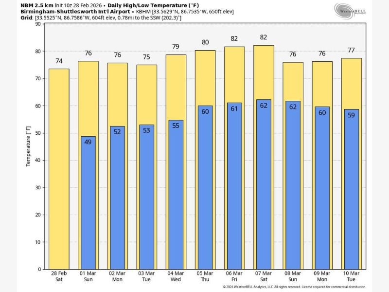
Data from Birmingham-Shuttlesworth International Airport shows daytime highs steadily rising from the mid-70s into the low 80s by the end of the week, as a strong upper-level ridge builds over the South Atlantic coast and influences regional conditions.
Warm Highs Build Through the First Week of March
Forecast daily highs for Birmingham and surrounding central Alabama communities show a consistent warming trend:
- February 28 (Saturday): 74°
- March 1 (Sunday): 76°
- March 2 (Monday): 76°
- March 3 (Tuesday): 75°
- March 4 (Wednesday): 79°
- March 5 (Thursday): 80°
- March 6 (Friday): 82°
- March 7 (Saturday): 82°
By late week, highs reach into the low 80s, marking well above-average temperatures for early March in central Alabama.
Even into early next week, temperatures remain elevated:
- March 8 (Sunday): 76°
- March 9 (Monday): 76°
- March 10 (Tuesday): 77°
The persistence of upper 70s and low 80s highlights a sustained mild stretch rather than a brief warm spike.
Overnight Lows Also Trend Milder
Overnight lows follow a similar upward trajectory, gradually warming from the upper 40s into the lower 60s:
- March 1: 49°
- March 2: 52°
- March 3: 53°
- March 4: 55°
- March 5: 60°
- March 6: 61°
- March 7: 62°
- March 8: 62°
- March 9: 60°
- March 10: 59°
These milder nighttime readings reinforce the influence of the developing ridge, preventing significant cooling after sunset.
Dry Conditions Dominate — For Now
The forecast discussion indicates generally dry weather across Alabama over the weekend and through much of next week, with only a few isolated showers possible later in the week.
This stable setup is linked to a high-pressure ridge positioned over the South Atlantic coast, limiting storm system movement into the region. As long as this ridge remains intact, Alabama will likely continue to experience calm, dry conditions.
However, longer-range model guidance suggests a potential pattern shift between March 7 and March 12, when the ridge may begin to break down. That transition could open the door for wetter and possibly stormier conditions returning to the state.
What This Means for Alabama Residents
For now, Alabama residents can expect a stretch of comfortable, above-average warmth — ideal for outdoor plans, early spring activities, and travel. The lack of widespread rainfall also allows soils to dry out following any recent precipitation.
The warming trend toward the low 80s late this week may feel more like mid-spring than early March. While no immediate severe weather concerns are highlighted in this outlook, residents should remain aware of updates as the potential pattern shift approaches next weekend.
The extended calm may not last indefinitely, but for the immediate forecast period, Alabama appears positioned for a stable, dry, and unseasonably warm start to March.
For more detailed regional weather breakdowns and ongoing forecast updates, visit NapervilleLocal.com for continued coverage.

I’ve lived in Naperville long enough to see how quickly our community changes — from new developments downtown to sudden shifts in our Midwest weather. Reporting on Naperville news and daily forecasts gives me the chance to keep neighbors informed about what really matters. My goal is simple: deliver clear, timely updates so you always know what’s happening in our city and what to expect from the skies above.