
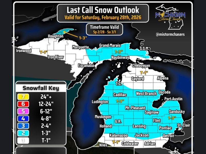
Michigan Snowfall Outlook for February 28, 2026: Lower Peninsula to See 1–3 Inches Overnight With Heavier Bands Near I-96 to M-46 Corridors
Michigan — A late-season clipper system is set to bring widespread light to moderate snowfall across much of the Lower Peninsula Saturday evening, with most communities expected to pick up 1 to 3 inches before daybreak Sunday.
The snowfall outlook valid for Saturday, February 28, 2026, indicates the system will primarily impact the Lower Peninsula, while portions of the Upper Peninsula see lighter accumulations and lake effect potential later tonight.
Snow Begins Around 5 PM and Moves West to East
Forecast guidance shows system snow developing around 5:00 PM EST, advancing from west to east across the state. The bulk of the precipitation is expected to wrap up before sunrise Sunday, roughly between 5:00 AM and 6:00 AM.
Travel impacts are expected to increase overnight as snowfall intensifies and temperatures hover in the mid-30s in southern sections. While some melting may occur at times, accumulating snow combined with overnight cooling could create slick conditions on untreated roads.
The greatest travel concerns are expected during the late evening and early overnight hours, particularly along major corridors.
Most of Lower Peninsula Forecast for 1–3 Inches
The snowfall map highlights a broad swath of 1–3 inches across much of central and northern Lower Michigan, including:
- Traverse City
- Cadillac
- Mount Pleasant
- West Branch
- Saginaw
- Flint
- Pontiac
- Port Austin
- Sandusky
The I-96 to M-46 corridors are noted as having the greatest potential for localized amounts above 3 inches if banding becomes more organized.
Further south, totals decrease slightly:
- Kalamazoo
- Jackson
- Coldwater
- Niles
These areas are projected for trace to 1 inch, with some melting likely given temperatures near or above freezing.
Along the southeastern corner near Detroit and St. Clair, lighter totals are also expected compared to central zones.
Upper Peninsula and Lake Effect Potential
In the Upper Peninsula, snowfall amounts appear lighter overall from this system:
- Ironwood: Trace to 1 inch
- Iron River: Trace to 1 inch
- Houghton: 1–3 inches
- Marquette: Minimal system snow
However, winds shifting to a northerly direction later tonight could introduce lake effect snow chances, particularly near Grand Marais and Naubinway, where 1–3 inches are projected.
The system’s moisture profile and wind direction will determine whether additional localized bands develop overnight in those northern shoreline communities.
Mixed Signals South of I-94
Forecast discussion notes some model disagreement regarding precipitation type south of I-94. While most snowfall should remain north of this corridor, there remains a slight chance of light drizzle mixing in if warmer air pushes farther north than expected.
Temperatures in the mid-30s across southern Michigan suggest that if snow does fall, accumulation may be partially offset by melting — especially on roadways that have been treated.
Bottom Line for Michigan Residents
This system is not expected to bring major totals, but 1–3 inches across a broad area combined with overnight timing could create localized travel issues late Saturday into early Sunday.
Drivers should plan accordingly if traveling after sunset, particularly along the I-96, M-46, and central Lower Peninsula routes. Conditions are expected to improve by mid-morning Sunday as snowfall tapers and road crews clear primary roadways. For continued winter weather updates and detailed snowfall tracking, visit NapervilleLocal.com for the latest forecast coverage.

I’ve lived in Naperville long enough to see how quickly our community changes — from new developments downtown to sudden shifts in our Midwest weather. Reporting on Naperville news and daily forecasts gives me the chance to keep neighbors informed about what really matters. My goal is simple: deliver clear, timely updates so you always know what’s happening in our city and what to expect from the skies above.