
Indiana Forecast for February 28, 2026: Spring-Like 60s and 70s South While Northwest Indiana Stays in the 30s and 40s
Indiana — A sharp temperature divide is shaping up across the state today as spring-like warmth spreads through central and southern Indiana, while northwest communities near the Michigan border remain stuck in much cooler air.
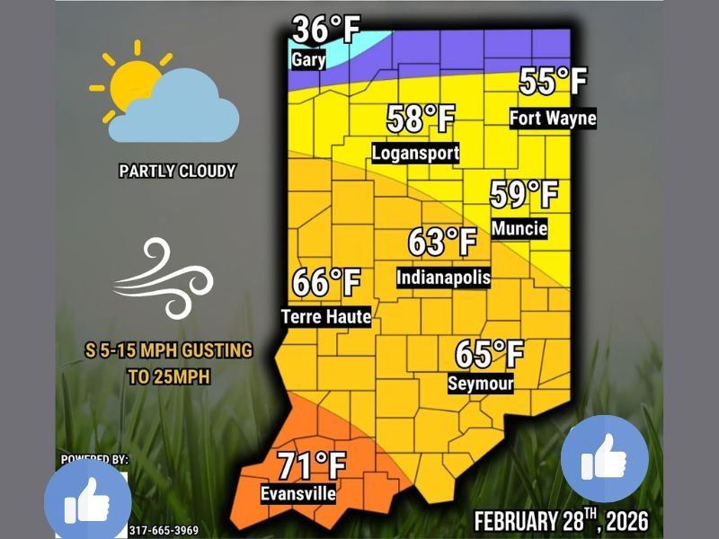
For Saturday, February 28, 2026, most of the state will experience partly cloudy skies, but temperatures will vary dramatically depending on location. A cold front pushing south later tonight will signal the beginning of a temporary return to winter conditions heading into the weekend.
Southern Indiana Warms Into the 60s and 70s
Communities across central and southern Indiana are forecast to enjoy well-above-average temperatures this afternoon.
Projected highs include:
- Evansville: 71°F
- Terre Haute: 66°F
- Seymour: 65°F
- Indianapolis: 63°F
- Muncie: 59°F
- Logansport: 58°F
- Fort Wayne: 55°F
Southwest Indiana stands out as the warmest region, with Evansville pushing into the low 70s — a notably mild reading for late February. Even central cities like Indianapolis are expected to reach the lower 60s under partly cloudy skies.
Winds from the south at 5 to 15 mph, gusting up to 25 mph, will help boost temperatures through the day, reinforcing the spring-like feel.
Northwest Indiana and IN/MI Border Remain Much Cooler
In contrast, areas near Lake Michigan and along the Indiana–Michigan border will remain significantly cooler.
- Gary: 36°F
Northwest Indiana communities and areas closer to Michigan are expected to stay in the 30s and 40s, creating a temperature spread of more than 30 degrees from north to south across the state.
This sharp divide highlights the influence of lingering colder air in the north, likely reinforced by proximity to Lake Michigan and the advancing frontal boundary.
Cold Front Brings Cooler Nights and Spotty Showers
Tonight, skies remain partly cloudy, but a few rain showers are possible as a cold front moves south across Indiana.
Overnight lows are expected to fall into the 20s and 30s statewide, signaling a clear shift from today’s daytime warmth. The cold front will gradually usher winter-like conditions back into the region for at least a short period.
The combination of falling temperatures and isolated evening showers means residents should be prepared for a noticeable change from today’s mild conditions.
A Brief Taste of Spring Before Winter Returns
Today’s forecast offers much of Indiana a preview of early spring, especially across central and southern counties. However, the cooler air mass sliding in tonight suggests the warmth will be temporary.
Residents in southern Indiana can expect a comfortable afternoon outdoors, while those in northwest Indiana should plan for heavier jackets and cooler conditions.
With temperatures ranging from the mid-30s in Gary to the low 70s in Evansville, February 28 delivers one of the most dramatic north-to-south contrasts of the season.
For continued regional weather updates and daily forecast coverage, visit NapervilleLocal.com for the latest reports.

I’ve lived in Naperville long enough to see how quickly our community changes — from new developments downtown to sudden shifts in our Midwest weather. Reporting on Naperville news and daily forecasts gives me the chance to keep neighbors informed about what really matters. My goal is simple: deliver clear, timely updates so you always know what’s happening in our city and what to expect from the skies above.