
TORCON 4 Tornado Risk Strikes Kansas, Nebraska and Colorado Today With Large Hail and Damaging Winds, Missouri and Illinois Targeted Father’s Day
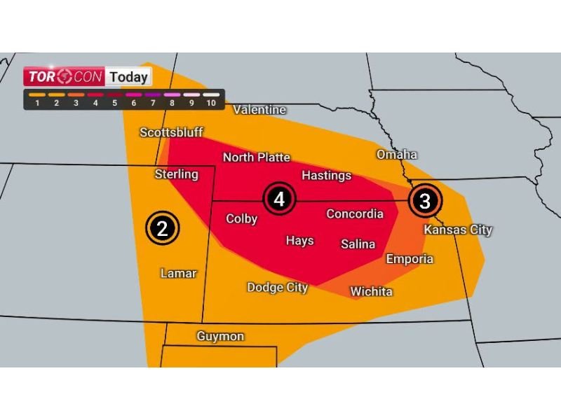
KANSAS — A significant severe weather threat with a TORCON 4 rating is in place today across Kansas, Nebraska, and Colorado, bringing the risk of tornadoes, large hail, and damaging winds to start the weekend. The highest threat zone, rated a 4 on the TORCON scale, stretches from North Platte and Hastings through Colby, Hays, and Salina.
A secondary TORCON 3 risk extends east toward Kansas City, while a TORCON 2 covers areas near Sterling and Lamar to the west. The threat then shifts east on Father’s Day, targeting Missouri, Illinois, and Indiana with another TORCON 4 outlook.
Highest Tornado Risk Centers on Central Kansas
The TORCON 4 zone today covers a broad swath including North Platte, Hastings, Colby, Hays, and Salina, where conditions are most favorable for tornado development. Forecasters say strong instability combined with sufficient wind shear will support the potential for supercell thunderstorms capable of producing tornadoes through the afternoon and evening hours.
Large Hail and Damaging Winds Add to the Danger
Beyond tornadoes, today’s setup includes a corridor of very likely to extreme large hail, with stones up to four inches in diameter possible near Limon, McCook, Colby, and Garden City. A separate damaging wind threat stretches from North Platte and Hastings through Colby, Hays, Salina, and Concordia, with gusts reaching up to 75 mph likely in the strongest storms.
Kansas City Region Faces Secondary Risk
A TORCON 3 risk extends across the eastern Kansas and Kansas City area, where tornadoes remain possible but at a slightly lower probability than the core TORCON 4 zone farther west.
Father’s Day Brings Tornado Threat to Missouri, Illinois and Indiana
The severe weather threat does not end today. A TORCON 4 risk is forecast for Sunday across Missouri and Illinois, including Columbia, St. Louis, and Effingham, with a TORCON 3 extending toward Springfield and a TORCON 2 near Branson and Poplar Bluff. Residents in the path are urged to have a safety plan ready.
Stay with NapervilleLocal.com for the latest weather updates and local forecast coverage.

I’ve lived in Naperville long enough to see how quickly our community changes — from new developments downtown to sudden shifts in our Midwest weather. Reporting on Naperville news and daily forecasts gives me the chance to keep neighbors informed about what really matters. My goal is simple: deliver clear, timely updates so you always know what’s happening in our city and what to expect from the skies above.