
Flash Flood Threat Returns to Gulf Coast as Stalled Front Soaks Louisiana, Mississippi and Alabama Through Saturday Night
LOUISIANA — A stalled frontal boundary along the Upper Gulf Coast is setting the stage for another round of heavy rainfall and flash flooding Saturday, with already saturated grounds raising the risk of rapid runoff and standing water. The Weather Prediction Center has placed much of Louisiana, Mississippi, and Alabama under a Slight Risk for excessive rainfall, embedded within a broader Marginal Risk stretching from the Florida Panhandle into the Tennessee Valley.
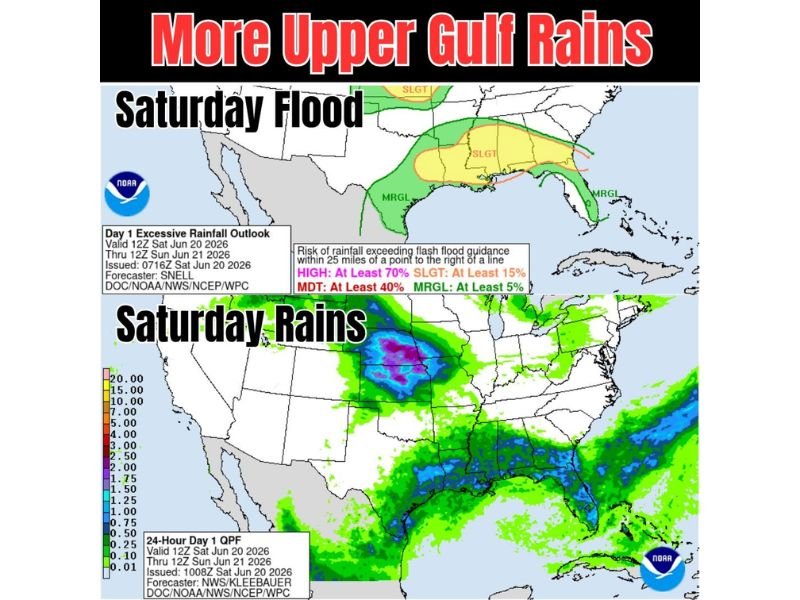
The outlook is valid from 12Z Saturday through 12Z Sunday. Localized downpours could quickly overwhelm flash flood guidance in spots already hit hard by recent rain.
Slight Risk Zone Targets Central Gulf Coast
The WPC Day 1 Excessive Rainfall Outlook shows a Slight Risk, indicating at least a 15 percent chance of rainfall exceeding flash flood guidance within 25 miles of a point. This zone covers a swath from southeast Louisiana through central Mississippi and into Alabama, with forecaster Snell noting the front remains nearly stationary over the region.
Saturated Ground Raises Flood Concern
Recent rainfall has left soils across the Gulf Coast already saturated, meaning additional downpours will run off quickly rather than soak in. The 24-hour QPF map shows widespread totals of 2 to 4 inches across the slight risk corridor, with isolated higher amounts possible where training storms develop.
Separate Heavy Rain Axis Over the Plains
A distinct area of heavy rainfall is also forecast over the central and northern Plains Saturday, with isolated totals approaching 7 to 10 inches indicated on radar-based guidance, according to forecaster Kleebauer. This activity remains separate from the Gulf Coast threat but adds to an active pattern across the country.
Marginal Risk Extends Into Florida and Tennessee Valley
A broader Marginal Risk area surrounds the slight risk zone, stretching into the Florida Panhandle, southern Tennessee, and northern Mississippi, signaling a lower but non-zero flooding threat across a wider footprint through Saturday night.
Stay with NapervilleLocal.com for the latest weather updates and local forecast coverage.

I’ve lived in Naperville long enough to see how quickly our community changes — from new developments downtown to sudden shifts in our Midwest weather. Reporting on Naperville news and daily forecasts gives me the chance to keep neighbors informed about what really matters. My goal is simple: deliver clear, timely updates so you always know what’s happening in our city and what to expect from the skies above.