
Oklahoma Soaked Overnight With Up to 2 Inches of Rain as Stronger Storm Threat Shifts Southeast Ahead of Cold Front
OKLAHOMA — Parts of the state woke up to soaking rain after overnight storms dropped between 0.5 and 2 inches across areas including Woodward, Cherokee, and Alva. While the heaviest rainfall stayed in northwest Oklahoma, attention is now turning to a shifting severe weather threat later this week.
Overnight Rain Totals Highest in Northwest Oklahoma
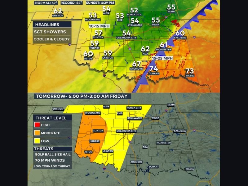
Communities such as Woodward, Cherokee, and Alva received the most rainfall, with totals reaching up to two inches in some locations. The steady overnight rain helped cool temperatures and brought cloudy skies into the morning hours.
Across central Oklahoma, lighter showers and patchy rain continue, with overcast skies keeping afternoon temperatures on the cooler side.
Cooler Air Settles Into Central Oklahoma
Afternoon temperatures are expected to remain mild to cool across cities like Oklahoma City (mid-50s), Stillwater (mid-50s), Ponca City (low-50s), Tulsa (mid-50s), and Clinton (upper-50s). Winds generally range from 10–15 mph, adding to the cooler feel compared to recent days.
Meanwhile, farther south near Ardmore and Durant, warmer air lingers ahead of an approaching cold front, with highs pushing into the 70s before cooler air arrives.
Severe Threat Focused on Southeast Oklahoma
The primary severe weather risk today is shifting into southeast Oklahoma, especially ahead of the advancing cold front. Areas near Ada, McAlester, Ardmore, and Durant fall within the zone where storms could strengthen later in the day.
While today’s severe threat is more limited, forecasters note that instability will increase farther southeast, where storms could produce gusty winds or small hail.
Higher Risk Expected Thursday and Friday
Attention is increasingly turning to Thursday and Friday, when conditions appear more favorable for stronger storms statewide.
Storm zone outlooks show expanding risk areas across much of Oklahoma, including:
- Central Oklahoma (Oklahoma City, Stillwater)
- Western Oklahoma (Clinton, Hobart, Altus)
- Southern Oklahoma (Ardmore, Durant)
- Eastern Oklahoma (Tulsa, McAlester)
Threats later this week include damaging winds, large hail, and a tornado risk, particularly if storms become more organized along and ahead of the frontal boundary.
Tornado Potential Being Monitored
A separate tornado zone outlook highlights portions of western and central Oklahoma for tomorrow evening into midnight. While exact placement may shift, the setup suggests that isolated tornadoes cannot be ruled out if storms remain discrete before merging into larger clusters.
Forecasters emphasize that details will continue to evolve as new data becomes available.
Residents across Oklahoma are encouraged to monitor updates closely as the state transitions from soaking rain to a more active severe weather pattern heading into the end of the week. Stay with NapervilleLocal.com for continued national weather updates as this system develops across the southern Plains.

I’ve lived in Naperville long enough to see how quickly our community changes — from new developments downtown to sudden shifts in our Midwest weather. Reporting on Naperville news and daily forecasts gives me the chance to keep neighbors informed about what really matters. My goal is simple: deliver clear, timely updates so you always know what’s happening in our city and what to expect from the skies above.