
Northern Colorado Braces for 60–80 MPH Wind Gusts, Smoke From Wyoming Fires, and Sudden Weekend Cold Front
COLORADO — A powerful stretch of windy and unusually warm weather is unfolding across northern Colorado, bringing wildfire smoke, elevated fire danger, and the potential for dangerous wind gusts reaching up to 80 mph in some areas.
Forecasters say the combination of strong winds, dry air, and above-normal temperatures is creating a volatile weather setup across the region before a sharp cold front arrives later this weekend.
Smoke From Wyoming and Nebraska Fires Spreads Into Northern Colorado
Weather conditions overnight allowed winds east of Interstate 25 to shift out of the northeast, funneling smoke from wildfires burning in Wyoming and Nebraska into northern Colorado.
Cities such as Greeley experienced thick smoke early in the morning, with residents reporting noticeably poor air quality and a strong smell of smoke in the air. Meteorologists expect that increasing daytime winds should help push the smoke out of the region, although conditions may remain hazy at times.
Strong Winds and High Fire Danger Continue Across the Region
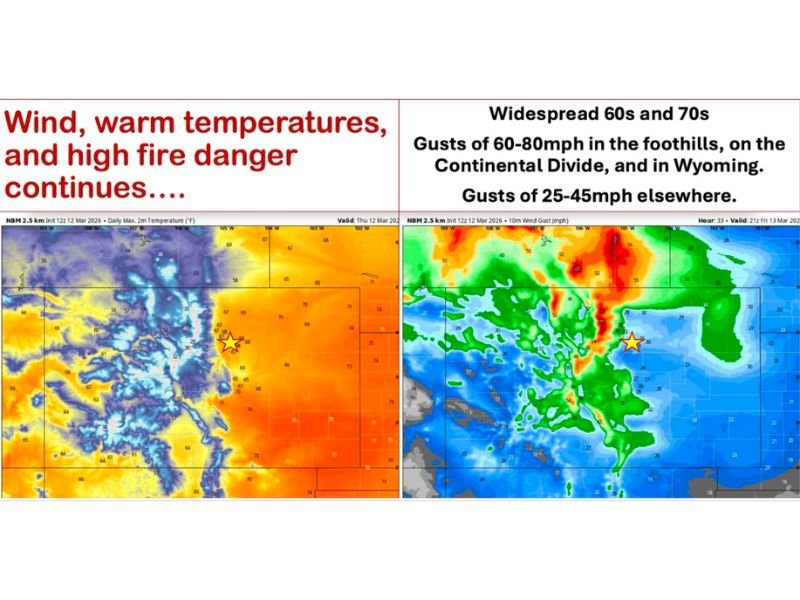
The region is now entering another day of strong winds and elevated wildfire risk. Temperatures across areas east of the Continental Divide are expected to climb into the 60s and 70s, unusually warm for this time of year. Similar warmth is also expected across the Western Slope.
At the same time, powerful wind gusts are forecast across multiple areas:
- 60 to 80 mph gusts possible in the foothills, along the Continental Divide, and into Wyoming
- 25 to 45 mph gusts expected across many other locations
These winds, combined with dry conditions, could significantly increase the risk of rapid fire spread if any new fires ignite.
Conditions Expected to Continue Into Saturday
The windy pattern is expected to persist through Saturday, keeping fire danger elevated across much of northern Colorado. Strong winds could also lead to travel difficulties in exposed areas, particularly for high-profile vehicles on east-west roadways. Residents are urged to remain cautious with outdoor burning or activities that could spark fires.
Major Weather Change Expected Late Weekend
After the stretch of warm and windy weather, a strong cold front is forecast to sweep through the region overnight Saturday.
This front will likely bring:
- A sharp drop in temperatures
- A shift to northerly winds
- A chance for light snowfall late Saturday night into Sunday
While precipitation amounts currently appear limited, forecasters say that localized heavier snow bands could still develop if enough moisture and atmospheric lift are present.
Dramatic Temperature Drop Possible by Sunday
The cold front could bring a dramatic shift in temperatures across the state. Some areas that see temperatures in the 70s Saturday afternoon may struggle to reach the 30s on Sunday, highlighting the dramatic weather swings that often occur in Colorado during March.
Light snow showers may linger mainly across the northern mountains and north of Interstate 70, while precipitation totals elsewhere are expected to remain relatively light.
Warmer Weather May Return Next Week
Looking ahead, forecast models indicate high pressure could rebuild across the region next week, allowing temperatures to climb again. By Tuesday and beyond, parts of the Front Range and eastern plains could once again see temperatures returning to the 70s or even 80s, although forecasters caution that spring weather patterns can shift quickly.
Residents are encouraged to stay updated on changing conditions as strong winds, fire danger, and a rapid weekend weather change continue to develop across northern Colorado.

I’ve lived in Naperville long enough to see how quickly our community changes — from new developments downtown to sudden shifts in our Midwest weather. Reporting on Naperville news and daily forecasts gives me the chance to keep neighbors informed about what really matters. My goal is simple: deliver clear, timely updates so you always know what’s happening in our city and what to expect from the skies above.