
Ohio High Wind Warning: Dayton, Celina, Troy and Wapakoneta Brace for 60 MPH Gusts as Powerful Winds Sweep Region
DAYTON, OHIO — A High Wind Warning is in effect across parts of western Ohio as powerful winds in the upper atmosphere begin transferring energy down toward the surface, creating sustained winds of 30 to 45 mph with gusts approaching 60 mph across several communities Friday morning.
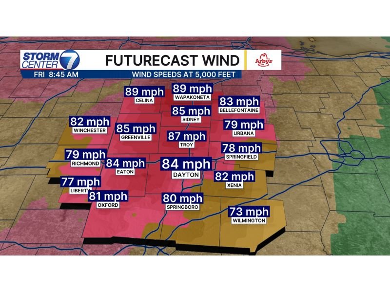
Meteorologists say winds roughly 5,000 feet above the ground are extremely strong, with forecast speeds between 73 mph and 89 mph across multiple cities. While not all of that wind reaches the surface, enough momentum is expected to mix downward to produce potentially hazardous conditions for several hours.
Powerful Winds Detected Above Western Ohio
Forecast data shows extremely strong wind speeds just above the surface across western Ohio Friday morning. Cities such as Celina and Wapakoneta are seeing winds near 89 mph at 5,000 feet, among the strongest values in the region. Nearby Sidney is forecast near 85 mph, while Troy could see upper-level winds around 87 mph.
These powerful winds in the atmosphere are significant because they can mix down toward the ground as daytime heating and atmospheric turbulence increase. Meteorologists say this process, known as momentum transfer, allows a portion of those stronger winds to reach the surface.
Dayton Region Faces Hours of Strong Gusts
The Dayton metro area is expected to experience sustained winds around 30 to 45 mph for several hours, with gusts potentially approaching 60 mph. Upper-level winds near 84 mph above Dayton indicate the atmosphere contains enough energy to support strong surface gusts throughout the day.
Other communities in the region are also experiencing strong winds overhead, including:
- Greenville – 85 mph
- Eaton – 84 mph
- Oxford – 81 mph
- Springboro – 80 mph
- Xenia – 82 mph
Because these strong winds exist across a broad area of western Ohio, multiple counties could see similar surface impacts.
Additional Cities Seeing Strong Winds Aloft
Farther east and south of the Dayton area, other cities are also seeing powerful winds above the ground. Forecast wind speeds around 83 mph above Bellefontaine, 79 mph above Urbana, and 78 mph above Springfield suggest the broader region is experiencing a significant wind event in the atmosphere.
Communities such as Richmond and Winchester are also within zones where upper-level winds range between 79 and 82 mph, increasing the likelihood of gusty surface conditions. Meanwhile, Wilmington is expected to see somewhat lower but still notable winds near 73 mph at 5,000 feet.
Why the Strongest Winds May Stay Above the Ground
Meteorologists emphasize that while winds above the surface are extremely strong, only a portion typically reaches ground level. The atmosphere acts as a buffer, preventing all of the energy from transferring downward. However, strong mixing during the daytime can still bring powerful gusts to the surface.
That is why officials issued the High Wind Warning, as the setup supports sustained winds strong enough to impact travel and outdoor conditions for several hours.
Windy Conditions Expected to Continue Through the Day
Forecasters say windy conditions will likely persist through much of Friday across western Ohio as the powerful atmospheric system continues moving through the region.
Drivers should expect difficult travel conditions on open roads, especially for high-profile vehicles. Loose outdoor objects may also be blown around in stronger gusts. Meteorologists continue monitoring the situation as strong winds move across cities including Dayton, Troy, Sidney, Celina, and Wapakoneta throughout the day.

I’ve lived in Naperville long enough to see how quickly our community changes — from new developments downtown to sudden shifts in our Midwest weather. Reporting on Naperville news and daily forecasts gives me the chance to keep neighbors informed about what really matters. My goal is simple: deliver clear, timely updates so you always know what’s happening in our city and what to expect from the skies above.