
Indiana and Illinois Face Dangerous Sunday Night Storm Setup as Tornado Risk Expands From Arkansas and Tennessee Into the Ohio Valley
INDIANAPOLIS, INDIANA — A dangerous severe weather setup is developing across the central United States for Sunday evening into the overnight hours, with forecasters warning of strong tornadoes and widespread damaging winds across multiple states. The latest forecast outlook highlights a corridor stretching from Arkansas and Tennessee through Kentucky and into Indiana and Illinois, placing parts of the Ohio Valley under heightened severe weather risk.
Meteorologists say the setup could produce both destructive wind events and tornadoes as storms move northeast through the region.
Tornado Risk Expanded in Latest Severe Weather Outlook
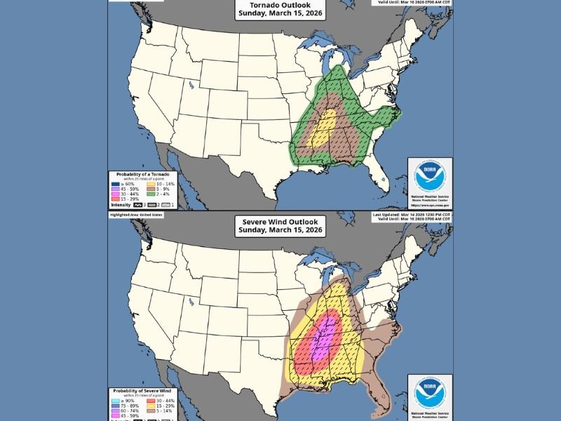
Forecasters recently expanded the tornado risk zone across parts of the central United States, introducing a 10 percent tornado probability area in the latest update. This risk area now includes portions of the ArkLaMiss region, Tennessee Valley, and sections of the Ohio Valley, signaling an increased chance for tornado development as storms intensify Sunday evening.
Cities across western Tennessee, northern Mississippi, Arkansas, Kentucky, and southern Indiana could all fall within the corridor where tornadoes may develop. Meteorologists say atmospheric conditions will support strong wind shear, a key ingredient for rotating thunderstorms capable of producing tornadoes.
Widespread Damaging Winds Expected Across Multiple States
In addition to tornado potential, forecasters are highlighting a significant threat for widespread destructive wind gusts. The updated outlook expanded a 45 percent probability zone for severe wind, indicating that a large area could experience damaging gusts as storms organize into a powerful line.
That wind corridor stretches from the lower Mississippi Valley northward into Illinois, Indiana, Kentucky, and Tennessee. Storm systems capable of producing widespread damaging winds can travel hundreds of miles, often bringing down trees, damaging buildings, and causing power outages across multiple states.
Storms Likely to Develop Sunday Evening and Continue Overnight
Current forecast guidance suggests the severe weather outbreak could begin developing during the late afternoon and evening hours Sunday before continuing through the overnight period.
As storms move northeast from the ArkLaMiss region toward the Ohio Valley, they may organize into a large storm complex capable of producing both tornadoes and intense wind gusts. Communities across Illinois and Indiana, particularly southern portions of the states, could see severe storms late Sunday night depending on the exact track of the system.
Dangerous Setup Requires Close Monitoring
Meteorologists say the evolving storm pattern represents a dangerous severe weather setup, particularly given the combination of strong wind energy and atmospheric instability expected across the region.
Because storms may continue into the overnight hours, residents across affected states are being urged to remain alert for weather warnings and ensure they have reliable ways to receive alerts. Forecasters emphasize that the exact location of the most intense storms could shift as new forecast data becomes available.
Officials say they will continue monitoring the developing storm system closely as Sunday approaches and additional updates are expected as meteorologists refine the timing and severity of the potential outbreak.

I’ve lived in Naperville long enough to see how quickly our community changes — from new developments downtown to sudden shifts in our Midwest weather. Reporting on Naperville news and daily forecasts gives me the chance to keep neighbors informed about what really matters. My goal is simple: deliver clear, timely updates so you always know what’s happening in our city and what to expect from the skies above.